マンハッタン【Manhattan】

![[一]](https://cdn.weblio.jp/e7/img/dict/sgkdj/exceptionalcharacters/02531.gif)
![[二]](https://cdn.weblio.jp/e7/img/dict/sgkdj/exceptionalcharacters/02532.gif)

マンハッタン

|
 |
|
||||||||||||||||||||||||||||||||||||||||||||||||
|
||||||||||||||||||||||||||||||||||||||||||||||||||
|
||||||||||||||||||||||||||||||||||||||||||||||||||
|
||
世界で最も有名なカクテルのひとつ「マンハッタン」の誕生には諸説あるが、第19代アメリカ大統領選のときに、かのチャーチル首相の母親がニューヨークのマンハッタン・クラブでパーティーを催したときに、ウイスキーとスイートベルモットの組み合わせを提案したという話。この新しいカクテルは参会者から好評を博し、クラブの名前にちなんで「マンハッタン」と名づけられたという。以来、“カクテルの女王”として「マティーニ」と並び称されている。ベースのウイスキーには、ライウイスキーを使うことが多い。 「カナディアンクラブ」は、カナダを代表する酒類メーカー・ハイラムウォーカー社がつくるカナディアンウイスキー。カナディアンウイスキーの特徴はライト&スムーズな口当たり。ハイラム・ウォーカー氏が1858年にカナダで作ったウイスキーは、当時の社交場に集まる紳士たちに好まれ、当時は“クラブ・ウイスキー”と呼ばれていた。「カナディアンクラブ」という名前になったのは1884年のこと。「C.C.」の相性で親しまれている。 「チンザノ ベルモット」は、200年以上の歴史を持つイタリアを代表するブランド。白ワインをベースにハーブや香草、スピリッツを加えて樽で醸造させたベルモットは、世界の約120ヶ国で愛飲されている。チンザノの代表製品の「エクストラ ドライ」はワイン本来の風味が生かされているやや辛口で、「ロッソ」は香草風味の甘口ベルモット。スイートベルモットのかわりにドライベルモットを使うと、「ドライマンハッタン」になる。そのときにはデコレーションにオリーブを使う。 |
マンハッタン
出典: フリー百科事典『ウィキペディア(Wikipedia)』 (2025/09/12 04:11 UTC 版)

| マンハッタン区(ニューヨーク市) ニューヨーク郡(ニューヨーク州) Manhattan Borough New York County |
|||
|---|---|---|---|
 |
|||
|
|||
| 愛称 : The City | |||
| 位置 | |||
 マンハッタン区 / ニューヨーク郡 |
|||
| 座標 : 北緯40度47分25秒 西経73度57分35秒 / 北緯40.79028度 西経73.95972度 | |||
| 行政 | |||
| 国 |  アメリカ合衆国 アメリカ合衆国 |
||
| 州 | ニューヨーク州 | ||
| 市 | ニューヨーク市 | ||
| 区/郡 | マンハッタン区(ニューヨーク市) ニューヨーク郡(ニューヨーク州) |
||
| 区長 | スコット・ストリンガー (民主党) |
||
| 地理 | |||
| 面積 | |||
| 区/郡域 | 87.46 km2 | ||
| 陸上 | 59.47 km2 | ||
| 水面 | 28.0 km2 | ||
| 水面面積比率 | 31.2% | ||
| 人口 | |||
| 人口 | (2020年現在) | ||
| 区/郡域 | 1,694,251人 | ||
| 人口密度 | 28,873人/km2 | ||
| 備考 | [1] | ||
| その他 | |||
| 等時帯 | 東部標準時 (UTC-5) | ||
| 夏時間 | 東部夏時間 (UTC-4) | ||
| マンハッタン区はニューヨーク市の行政区、ニューヨーク郡はニューヨーク州の郡。両者の領域は同じ。 | |||
| 公式ウェブサイト : Manhattan Borough President | |||


マンハッタン(Manhattan、英語発音: [mænˈhætn])は、アメリカ合衆国ニューヨーク州ニューヨーク市の地区。
ハドソン川河口部の中州であるマンハッタン島 (Manhattan Island)、あるいは、マンハッタン島が大部分を占めるマンハッタン区 (Manhattan Borough) のことである。ニューヨーク州のニューヨーク郡 (New York County) の郡域もマンハッタン区と同じである。マンハッタンはニューヨーク市の中心街とされる。
ニューヨーク州の行政上の州都はニューヨーク市の北233キロメートルにあるオールバニに置かれているが、アメリカ最大の都市圏人口を背景にした経済・文化面の影響力により、ウォール街を擁するニューヨーク市のマンハッタンがニューヨーク州の中心であるといえる。
概要

ニューヨーク市を構成する5つの行政区の1つであり、ニューヨーク市役所の所在地である。他の4区はクイーンズ区・ブルックリン区・ブロンクス区・スタテンアイランド区である。
5番街やタイムズスクエアなどの繁華街があり、世界中からの観光客をひきつけている他、世界を代表する金融街の一つであるウォール街がある。また国連本部はマンハッタン島に置かれているが、この土地は全加盟国で共有する国際領土となっている。一般的に「ニューヨーク」と言えば、ニューヨーク州ではなく、ニューヨーク市とりわけマンハッタンを意味することが多い。
マンハッタンはアメリカ最大の都市圏人口を持つニューヨーク市(約800万人)の中心であり人口は約160万人と推定されている。イタリア系やユダヤ系、中国系、プエルトリコ系など多くの人種が混在する街であり、地域ごとに異なった文化が形成されている。また、「人種のるつぼ」「ビッグ・アップル」などと称される。
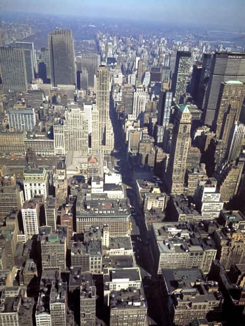
またニューヨークではシカゴとともに19世紀後半から世界に先駆けて高層ビルの建設が始まり、マンハッタンには多数の超高層ビルが密集している。これらは『摩天楼』と呼ばれ、象徴的なマンハッタンの景観を形成している。
地理


マンハッタン区は、マンハッタン島と小さな諸島(ルーズベルト島、ガバナーズ島、エリス島、ランドールズ島、ワーズ島、ミル・ロック、ウ・タント島)、そして北米大陸のごく一部地域(マーブル・ヒル)からなる[注釈 1]。
マンハッタン島
マンハッタン島は、西をハドソン川、東をイースト川とハーレム川、北をスパイテン・ダイヴィル川(およびハーレム川運河)、南をアッパー・ニューヨーク湾によって囲まれている。幅は約4 km、長さ約20 kmで、ほぼ南北方向に細長い形状をしている。面積は58.8 km2で、東京の山手線の内側(約64 km2)にほぼ相当する。ブロンクスに隣接するマーブル・ヒルもかつてはマンハッタン島の一部であったが、スパイテン・ダイヴィル川の付け替えにより現在はマンハッタン島から分離している。
マンハッタン島は1枚の岩盤から構成されており、島の大部分を構成している基盤岩はマンハッタン片岩 (Manhattan Schist) と呼ばれる雲母の結晶片岩である。この岩は強度が高く、その構成成分の変成岩はパンゲア大陸が形成された過程で作られた。この岩盤上は高層ビルの建設に適しており、ダウンタウンとミッドタウンの表面はこの岩石に富んでいるためこれらのエリアには高層ビルが多く建ち並んでいる[2][3]。セントラルパークにはマンハッタン片岩の露頭があり、ラット・ロックはその一例である[4][5]。
地形は沿岸部に向かって極緩い傾斜があるほか、ダウンタウンからアップタウンに向けては緩やかに上る地形となっている。これはコロンビア大学付近を頂上とし、モーニングサイド・ハイツなどの高所を抜けると北に向けて大きく下がり125丁目が谷間となる。そこから北は再び高度は上がり、マンハッタン北部のインウッドまで高台が続く。埋め立ては、沿岸の埠頭部分などに限られている。
その他の小島
ルーズベルト島は、マンハッタン島の東を流れるイースト川の中州であり、南北に細長い島である。その先はクイーンズ区となる。ニューヨーク市地下鉄の駅があり、マンハッタン島とはルーズベルト・アイランド・トラムウェイ(ロープウェイ)でも結ばれている。
ガバナーズ島はマンハッタン島の南のニューヨーク湾にある。かつては、マンハッタン島の至近距離にありながら、沿岸警備隊の中枢施設があり公共輸送機関はなかった。しかし、2003年1月に国から州および市へ1ドルで売却され、一般に開放されて、現在ではマンハッタン島南端のバッテリー・パークからフェリーが運航されている。イギリス植民地時代の総督の保養地であり、独立戦争では対英軍のための要塞、南北戦争では南軍の捕虜収容所となった。
エリス島は、マンハッタン島の南西部ハドソン川河口付近にあり、移民博物館となっている。こちらへもバッテリー・パークからフェリーが運航されている。
いずれの島も、マンハッタン島との間の橋はない。ルーズベルト島は、クイーンズに繋がる橋がある。橋の数が少ないのは意図的なものでマンハッタンからの経済流出を防ぐためである。そのため、マンハッタン区とその他のニューヨーク市区域の光景は大きく異なる。東側のイースト川には、クイーンズ/ブルックリン地区と結ぶ5本の橋が、ハーレム川には15本の橋が架かっている。また、地下鉄の線路が7本走る。これに対しニュージャージー州(西側・ハドソン川)には橋が1本、道路トンネルが2箇所、鉄道トンネルが2本通っているのみである。これは、イースト川は市内を流れる川であるのに対し、ハドソン川は州を区切る川であることによる。合衆国において、州が独立性の高い構成単位であることを示していると言われる。
- 地名
Manhattanの名はインディアン部族のデラウェア(レナペ)語の「丘の多い島」を意味する "Mannahate"、"Manna-hata" に由来するとされる。一方、レナペ族は宣教師のジョン・ヘッケウェルダーに、"Manahachtanienk"(マナハクタニエンク)から来たと説明している。これは「我々がみな、酔っぱらいにされた島」という意味である。
気候

緯度としては日本の青森県に位置し、やや冷涼な気候ではあるが、区分上は温帯気候である。
- 春:冬の期間が長く、春は4月頃から始まる。
- 夏:気温は最高でも摂氏約33〜5度程度であるが、多湿であり、体感温度は高い。いわゆる盛夏は1か月程度である。6月くらいから9月中旬。
- 秋:9月下旬から10月の短い期間。
- 冬:11月〜3月までと冬は比較的長い。セントラルパークの沼が完全に凍るなど冷え込みは厳しく摂氏-10度程になり、海からの風により体感温度は最低-25度近くになることもある。
ハリケーンの進路に当たることもあるが、大西洋岸を北上する途中で勢力を弱めることが多い。夏場には夕立が多い。梅雨がないので降雨量は日本に比べ少ない。冬場の冷え込みは厳しいが、降雪はそれほど多くない。降った場合でも街の熱と除雪により直ぐに除去される。気温は日中でも摂氏マイナス10〜15度ほどになる。沿岸都市のため、海から吹く風が強い日が秋を中心に見られ、体感温度を下げる。湿度は比較的低い。都市部特有のヒートアイランド現象の影響がある。秋・冬は北方からの冷たい空気、夏は大西洋南方からの暖かい空気により気温の変化がもたらされる。
人口
| 統計年 | 人口 | 増減率 |
|---|---|---|
| 1656 | 1,000 | - |
| 1698 | 6,788 | +578.8% |
| 1711 | 10,538 | +55.2% |
| 1730 | 11,963 | +13.5% |
| 1731 | 8,628 | −27.9% |
| 1756 | 15,710 | +82.1% |
| 1773 | 21,876 | +39.2% |
| 1774 | 23,600 | +7.9% |
| 1782 | 29,363 | +24.4% |
| 1790 | 33,131 | +12.8% |
| 1800 | 60,489 | +82.6% |
| 1810 | 96,373 | +59.3% |
| 1820 | 123,706 | +28.4% |
| 1830 | 202,589 | +63.8% |
| 1840 | 312,710 | +54.4% |
| 1850 | 515,547 | +64.9% |
| 1860 | 813,669 | +57.8% |
| 1870 | 942,292 | +15.8% |
| 1880 | 1,164,674 | +23.6% |
| 1890 | 1,441,216 | +23.7% |
| 1900 | 1,850,093 | +28.4% |
| 1910 | 2,331,542 | +26.0% |
| 1920 | 2,284,103 | −2.0% |
| 1930 | 1,867,312 | −18.2% |
| 1940 | 1,889,924 | +1.2% |
| 1950 | 1,960,101 | +3.7% |
| 1960 | 1,698,281 | −13.4% |
| 1970 | 1,539,233 | −9.4% |
| 1980 | 1,428,285 | −7.2% |
| 1990 | 1,487,536 | +4.1% |
| 2000 | 1,537,195 | +3.3% |
| 2010 | 1,585,873 | +3.2% |
| 2018 | 1,628,701 | +2.7% |
| 参考文献[6][7][8] | ||
| アメリカ合衆国国勢調査局[9] | ||
以下はマンハッタンの人種別の人口構成。
| 人口構成 | 2018年[10] | 2010年[11] | 1990年[12] | 1950年[12] | 1900年[12] |
|---|---|---|---|---|---|
| コーカソイド(白人) | 64.5% | 57.4% | 58.3% | 79.4% | 97.8% |
| 他の人(ヒスパニック系ではない) | 47% | 48% | 48.9% | 不明 | 不明 |
| アフリカ系アメリカ人(黒人) | 17.9% | 15.6% | 22.0% | 19.6% | 2.0% |
| ヒスパニック(人種は様々) | 25.9% | 25.4% | 26.0% | 不明 | 不明 |
| アジア系 | 12.8% | 11.3% | 7.4% | 0.8% | 0.3% |
宗教
マンハッタンは宗教的に多様である。 2000年に最大の宗教的所属はカトリック教会で、564,505人の支持者(人口の36%以上)で、110の会衆を維持していた。 ユダヤ人は、102の会衆で314,500人(20.5%)の2番目に大きい宗教グループを構成した。3番目はプロテスタント、139,732人のフォロワー(9.1%)、4番目はイスラム教徒、37,078(2.4%)である[13]。 ヒンズー教、無神論および無宗教を含む他の宗教的所属が、残りの大半を構成した。
言語
2010年時点で、5歳以上のマンハッタン居住者の59.98%(902,267人)は自宅で英語のみを話し、23.07%(347,033人)スペイン語、5.33%(80,240人)中国語、2.03%(30,567人)フランス語、0.78%(11,776人)日本語 、0.77%(11,517人)ロシア語、0.72%(10,788人)韓国語、0.70%(10,496人)ドイツ語、0.66%(9,868人)イタリア語、0.64%(9,555人)ヘブライ語、0.48%(7,158人)自宅でアフリカ言語を話している。 合計で、5歳以上のマンハッタンの人口の40.02%(602,058人)は、自宅で英語以外の言語を話した[14]。
歴史


ニューヨーク州はアメリカ建国13州のうちの11番目の州である。
もともとこの地には、レナペ族(デラウェア族)、ワッピンガー族などのインディアン部族がウィグワムによる移動型集落を形成し、トウモロコシや豆、カボチャなどを栽培し、狩猟採集の生活を営んでいた。領土的にはレナペ族がほぼ独占していた。
- 1524年:レナペ族の乗るカヌーが、探検家ジョバンニ・ダ・ヴェラッツァーノの船と現在でいうニューヨーク港で出会っている。彼はロングアイランドとスタテンアイランドを発見したが、マンハッタン島には到達しなかった。
- 1609年:オランダ人の資金援助でマンハッタンにたどり着いたヘンリー・ハドソンの名がハドソン川の由来となっている。ハドソンの船の乗組員のロバート・ジュエットは、この島について航海日誌に「マンナ・ハッタ (Manna-hata)」と記述している。
- 1613年:オランダ人の毛皮取引商Juan Rodriguezが、商売のためにマンハッタン島に到達し、ヨーロッパ人で初めて現在のニューヨーク市域内の住人となった。
- 1614年:オランダ人アドリアン・ブロックの探検したエリア(ニューヨークを含む)に、祖国の名にちなんだニーウ・ネーデルラントの設立が宣言された。
- 1624年:ガバナーズ島がニーウ・ネーデルラントの最初の恒久的入植地となる。
- 1625年:マンハッタン島最南端にフォート・アムステルダムが建設され、ニーウ・ネーデルラントの首都としてニーウ・アムステルダムがこの場所に設立された。この年が、ニューヨーク市の公式創立年となっている。
- 1626年:この年、オランダ西インド会社がマンハッタンを「インディアンたちから24ドル相当で買い取った」と一般に言われている。が、これは実際には、60ギルダー分の交易品との交換だった。60ギルダーがどれくらいの価値かというと、「1626年当時に、ビールの大ジョッキを2400杯買うことができるくらいの金額」である。ただしオランダ人入植者に「マンハッタンを売った」という部族は、レナペ族ではなく、実はマンハッタン島を縄張りにしておらず、レナペ族とオランダ人の抗争の漁夫の利を狙って騙したのだった。また、そもそもインディアンには「土地を金で売る」という文化は無かったので、この取引自体理解していたかどうか疑わしい。実際、島を買い取ったと思い込んだオランダ人とレナペ族とは長く抗争が続いた。
- 1664年:イングランド国王チャールズ2世の弟、ヨーク公ジェームズ(後のジェームズ2世)が第二次英蘭戦争に勝利し、この地を制し、現在の市名ニューヨークに改名した。


- 1776年:アメリカ独立戦争ニューヨーク・ニュージャージー方面作戦においてマンハッタンは、キップス湾の上陸戦(9月15日)、ハーレムハイツの戦い(9月16日)およびワシントン砦の戦い(11月16日)の舞台となった。これらの戦いの後、ニューヨークはイギリス軍に占領された。
- 1783年:イギリス軍がニューヨークから撤退(撤収の日参照)。
- 1785年-1788年:連合規約の下で、ニューヨークが第5代目の首都となる。
- 1789年:東海岸の都市の中でも発展を見せていたニューヨークは、ジョージ・ワシントンが初代大統領に就任した年、わずか1年だけ合衆国憲法の下で最初の首都となった(その後、フィラデルフィア、続いてワシントンD.C.へ移動)。
- 1792年:すずかけ協定によってニューヨーク証券取引所が設立される。
- 1811年:ニューヨーク州政府が、マンハッタン島北部の都市計画「1811年委員会計画」を策定。これにより、マンハッタンの農場を結ぶブルーミングデール・ロード(現在のブロードウェイ)を除き、地形や旧道に関係なくグリッド状の街区が形成されることとなる。
- 1853年:ニューヨーク州議会により正式にセントラル・パークが公園用地として指定される。
- 1870年:メトロポリタン美術館が開館。
- 1886年:エリー運河の開通以降、市には続々と移民が押し寄せ大都市へと発展した。移民を迎え入れる自由の国の象徴としてフランスより自由の女神像が贈呈された。
- 1898年:マンハッタンとウェスト・ブロンクス(1873年にマンハッタンだけであったニューヨーク市に併合、1895年にもウェスト・ブロンクスの残りの地区が併合される)だけであったニューヨーク市が、イースト・ブロンクス、ブルックリン、クイーンズ、およびスタテンアイランドを併合し現在と同じ範囲となる(シティ・オブ・グレーター・ニューヨーク参照)。
- 1904年:ニューヨーク市地下鉄の最初の路線がマンハッタン島を南北に開通。
- 1929年:10月24日にニューヨーク株式市場(ウォール街)で株価が大暴落したことに端を発した世界恐慌が起こる。
- 1931年:エンパイア・ステート・ビルディングが完成。
- 1945年:エンパイア・ステート・ビルディングにアメリカ陸軍航空隊のB-25爆撃機が激突。
- 1998年:ニューヨーク市は市制に移行して200年、5区になって100年を迎えた。
- 2001年:9月11日にアメリカ同時多発テロ事件が起こり、世界貿易センタービルの両棟が破壊された。
- 2022年:ロシアのウクライナ侵攻などを要因にインフレが進行。家賃相場の例では前年に比べ30%近く上昇し平均5000ドル、中央値でも4000ドルを上回った[15]。一方で新型コロナウイルス感染症拡大、それに伴うテレワークの増加はオフィス需要にも及び、家賃が高騰したまま需要自体は減る現象が見られた[16]。
マンハッタンのスカイライン

地区


通り
地図上の南北をあらわす向きから、マンハッタン島内の最南端ロウアーマンハッタンを中心に「ダウンタウン」と呼び、北側を「ミッドタウン」および「アップタウン」と呼ぶ。ニューヨーク市地下鉄などの交通機関での行先・方面表示にもダウンタウン・アップタウンの表記が使われる。一方、マンハッタン島内の東西に走るバスや地下鉄などは「クロスタウン」とよばれる。ブロードウェイはマンハッタン島の最南端から最北端まで貫く通りで、元々はインディアンの小道であった。
日本語では、マンハッタンにおける東西方向の道(クロスタウン・ストリート)に付けられる名称「Street(ストリート)」を「――丁目」、南北方向の道である「Avenue(アベニュー)」を「――番街」と呼称するのが慣例となっている。有名な5番街 (マンハッタン)は「フィフス・アベニュー」である。ニューヨークに関する著作の多い作家、常盤新平は、次のように述べている[17]。
(マンハッタンの)数字のストリートについては僕は丁目と訳してきた。たとえば、フォーティー・セカンド・ストリートを42丁目と訳せるのが嬉しいのだ。ストリートに対応する『丁目』というのがあるのは素晴らしいことだと思う。(中略)ニューヨークを舞台にした小説を読んでいて、57番ストリートとか、42番ストリートと訳してあるのをみると、とたんにページを閉じてしまいたくなる[17]。
フィフス・アヴェニューは、僕は5番街と書く。パーク・アヴェニューはパーク・アヴェニューで、パーク街と書くことはない。パーク街ではなんだかみすぼらしい感じがする。マディスン・アヴェニューは、マディスン街と書くこともある。
マンハッタン島内で一番大きな数字の通りは、ストリートは220丁目(マーブル・ヒルまで含めたマンハッタン区では228丁目)でアベニューは13番街である[注釈 2]。当初の1811年委員会計画では115丁目までの予定だったが[18]、後にマンハッタンの北端の220丁目まで格子状道路は拡張された。東から西へ、または南から北へ進むにつれて数字は増えていく。
これらのアベニューの道幅は100フィート (30 m)で、クロスタウン・ストリートの道幅は通常60フィート (18 m)だが、そのうち15は100フィート (30 m)の道幅で作られている。両方向通行の34丁目、42丁目、57丁目や125丁目などがそうで、これらの通りはショップが充実している[19]。クロスタウン・ストリート間のブロックの幅は約200フィート (60 m)で、アベニュー間のブロックの幅は約は800フィート (240 m)である。
マンハッタンの大部分の通りは厳密な格子状に計画的に作られた結果、マンハッタンヘンジ(ストーンヘンジの派生語)と呼ばれる現象を年に二回見ることができる。これは、その東西の通りは真の東西方向から約28.9°傾いているため、夏至を挟んで約20日前後の日は太陽が東西の通りのちょうど中心に沿った地平線に沈むという現象である。マンハッタンヘンジが起きる日没時には、ビルの間をまっすぐ太陽の光が伸びてくるのを目にすることができる。
ネイバーフッド
マンハッタンはその特徴などから、さらに細かく特定のエリア(ネイバーフッド)を指して以下のような名称(愛称)が付けられている。地区毎の特徴はリンク先項目およびマンハッタンの地区名の一覧を参照のこと。
- フィナンシャル・ディストリクト
- シヴィック・センター
- サウス・ストリート・シーポート
- トライベッカ
- チャイナ・タウン
- リトル・イタリー
- ソーホー
- ロウアー・イースト・サイド
- グリニッジ・ヴィレッジ
- イースト・ヴィレッジ
- ミートパッキング・ディストリクト
- 14丁目の西端付近一帯をいう。かつてはガンゼヴォート・マーケットとして知られていたが、20世紀前半に精肉業種の工場などが多く立地したことからこの地域呼称が付けられた。1990年代後半から高級化が進み、有名ブランド店やレストランなど注目が集まるような出店があったことからエリアとしての認識が高まった。
- マディソン・スクエア・パークの南の一帯をいう。ハイテク産業が多く集まっていたことから、シリコン・バレーをもじったシリコン・アレーがこの地から広まった。
- ノマド
- マディソン・スクエア・パークの北の一帯 (NOrth of MADison Square Park) をいう。一時は廃れていたが、近年ブティックやレストラン街として再び活性化してきている。
- 41丁目から53丁目付近のレキシントン街より東の一帯をいう。グランドセントラル駅のすぐ東のエリアで、国連本部も所在するオフィス街である。日本企業のオフィスも多く、そのため日系レストランや居酒屋も多く所在する。2番街沿いにはバーが多く並ぶ。
- ガーメント・ディストリクト
住所
マンハッタン島内における主要な通りの住所を見つけるにはマンハッタン住所算法が一般に用いられる。これはニューヨーク市の電話帳やガイドブックの他、MTAバスの地図でも用いられている。
経済


ニューヨーク証券取引所やウォール街が代表するように、シティグループやCBS、メットライフやモルガン・スタンレーなどがひしめく、アメリカの経済の中心地であり、アメリカを代表する大企業の本社が多数存在する。メディア、ファッションや広告業界の世界的な中心地のひとつであり、また、芸術面でも大きな影響力を持つと評価されている。
マンハッタンに本拠を置く企業
- シティグループ
- JPモルガン・チェース
- アメリカン・エキスプレス
- メットライフ
- モルガン・スタンレー
- ゴールドマン・サックス
- メリルリンチ
- ダウ・ジョーンズ
- ブルームバーグ
- ニューヨーク・タイムズ
- CBS
- タイム・ワーナー
- オグルヴィー&メイザー
- マッキャンエリクソン・ワールドワイド
- ラルフ・ローレン
- トミーヒルフィガー
- ダナ・キャラン
- ディーン・アンド・デルーカ
文化
マンハッタンには多くの世界的に有名な美術館や博物館が所在しており、その芸術コレクションは世界有数である。また劇場やコンサートホールなどの文化施設も充実している。
文化施設
- 劇場・コンサートホール・スタジアム
- リンカーン・センター
- カーネギー・ホール
- ラジオシティ・ミュージックホール(ロックフェラー・センター内)
- ブロードウェイ・シアター
- マディソン・スクエア・ガーデン
- アポロ・シアター
- 美術館・博物館
マンハッタンに本拠を置くスポーツチーム
- ニューヨーク・ニックス (NBA)
- ニューヨーク・レンジャース (NHL)
- ニューヨーク・リバティ(WNBA、ホームスタジアムはプルデンシャル・センターだがマディソン・スクエアガーデンをホームとして使用することもある)
- かつてマンハッタンに本拠を置いていたスポーツチーム
- ニューヨーク・ジャイアンツ(MLB、現サンフランシスコ・ジャイアンツ)
- ニューヨーク・ヤンキース (MLB)
- ニューヨーク・メッツ (MLB)
- ニューヨーク・ジャイアンツ (NFL)
- ニューヨーク・ジェッツ (NFL)
- ニューヨーク・コスモス (NASL)
観光


ランドマークと見どころ
- セントラル・パーク
- 国連本部ビル
- メトロポリタン美術館
- ニューヨーク近代美術館 (MoMA)
- アメリカ自然史博物館
- 5番街
- グランド・セントラル・ターミナル
- ロックフェラーセンター
- リンカーン・センター
- カーネギー・ホール
- コロンビア大学
- ゲデス・フォークシティ
- マディソン・スクエア・ガーデン
- ブロードウェイ
- タイムズスクエア
- ワシントン・スクエア
- ハイライン
- クライスラー・ビルディング
- エンパイア・ステート・ビルディング
- フラットアイアンビルディング
- ウォール街
- ニューヨーク証券取引所
- ワールドトレードセンター
- ダコタ・ハウス
- グリニッジ・ヴィレッジ
- リトル・イタリー
- チャイナ・タウン
- 教会
- パブリックアート
公園
- アフリカ人墓地ナショナル・モニュメント
- クリントン城ナショナル・モニュメント
- フェデラル・ホール国定記念物
- グラント将軍国定記念物
- ガバナーズ島ナショナル・モニュメント
- ハミルトン・グレインジ国定記念物
- ロウワー・イースト・サイド・テネメント記念館
- 自由の女神ナショナル・モニュメント(エリス島およびリバティ島を含む国定歴史保護地区。このうちエリス島の一部はマンハッタン区に含まれる。)
- セオドア・ルーズベルト生誕地国立史跡
建築
ニューヨークはシカゴとともに1880年頃から1930年頃までに建てられた初期の高層ビルが多く存在する街である。このためマンハッタンでは、ネオゴシック様式、ボザール様式やアールデコ様式といった特徴的な初期の高層建築を近代的なビルとともに見ることができる。クライスラー・ビルディングとエンパイア・ステート・ビルディングはアールデコ様式の代表作であり、リーバ・ハウス、国連本部ビルとシーグラム・ビルディングはインターナショナルスタイルの代表作であるとされる。シカゴのシアーズ・タワーが1973年に完成するまで、世界一高い高層ビルの多くはマンハッタンに建てられたビルであった。
- かつて世界一高かった高層ビル
- ニューヨークワールドビル(1955年解体)
- マンハッタンライフビル(1930年解体)
- パークロウビル
- シンガービル(1968年解体)
- メトロポリタンライフタワー
- トランプビル
- ウールワースビル
- クライスラー・ビルディング
- エンパイア・ステート・ビルディング
- 旧ワールドトレードセンター(2001年アメリカ同時多発テロ事件により倒壊)
- 20世紀後半の特徴的な高層ビル
- 高層ビル登場以前の古い建築
- フランシス・タバーン - 1719年築。現存するマンハッタン最古の建築物をうたっているが、1832年から1852年にかけて火災の修復のため大部分が改築されている[注釈 3]。
- セント・ポール教会 - 1764年築。現存するマンハッタン最古の教会堂。ニューヨーク市の教会堂の中でも三番目に古い[注釈 4]。
- モリス=ジュメイル・マンション (en) - 1765年築。
- ダイクマン・ハウス - 1784年築。マンハッタンに現存する唯一の農家。
- エドワード・ムーニー・ハウス - 1785年築。現存するマンハッタン最古のテラスハウス。
- ブリッジ・カフェ - 1795年築。現存するマンハッタン最古の木造建築。
- グレイシー・マンション - 1799年築。ニューヨーク市長官邸。
ショッピング
マンハッタン内および周辺エリアの住人の平均収入が高い上、世界各国から観光客が集まるため、これらの高所得層をターゲットにしたデパートやブティック、ショッピングモールが多数存在する。
デパートおよびショッピングモール


- サックス・フィフス・アヴェニュー
- バーグドルフ・グッドマン
- ブルーミングデールズ
- バーニーズ・ニューヨーク
- メイシーズ
- ロード・アンド・テイラー
- ヘンリ・ベンデル
- トランプ・タワー
- タイム・ワーナー・センター
ブランド店
その他
- チェルシー・マーケット
- ライムライト・マーケットプレイス
- ディーン・アンド・デルーカ
ホテル
アメリカの金融、メディアの中心地であるだけでなく、上記のように多数の観光名所があるので、ランドマーク的な最高級ホテルから国際チェーンの大規模ホテル、デザイナーズホテル、長期滞在用の格安ホテルまで揃っている。ビジネス、観光客のいずれもが年間を通じて訪れるので、ホテルの稼働率はきわめて高い。特に高級ホテルは国連総会の期間中の稼働率が高くなる。
最高級ホテル

- ウォルドルフ=アストリア
- プラザ・アテネ・ニューヨーク
- プラザホテル
- ザ・ピエール
- ジュメイラ・エセックスハウスホテル
- セント・レジス
- フォーシーズンズ・ホテル・ニューヨーク
- マーク
- シェリー・ネザーランド
- トランプインターナショナル・ホテル・ニューヨーク
- リッツ・カールトン・ニューヨーク
- マンダリン・オリエンタル・ニューヨーク
- ペニンシュラ・ニューヨーク
- ザ・セタイ・フィフスアベニュー
高級ホテル
- ニューヨーク・ヒルトン
- ニューヨーク・マリオット・マーキス
- シェラトン・マンハッタン・アット・タイムズスクエア
- シェラトン・ニューヨーク・ホテル&タワーズ
- Wニューヨーク
- グランド・ハイアット
- ソフィテル・ニューヨーク
- ミレニアム・ブロードウェイ
- ウェスティン・ブロードウェイ
- アルゴンキン・ホテル
- キタノ・ニューヨーク
- ル・パーカー・メリディアン
中級ホテル
- ニューヨーク・ヘルムズレイ
- ヘルムズレイ・ミドルタウン・ホテル
- ミレニアム・UNプラザ
- ホリデイ・イン・ミッドタウン・マンハッタン
- ホリディ・イン・ブロードウェイ
- ノボテル・ニューヨーク
- コンフォート・イン・マンハッタン
- ロー・NYC・ホテル・アット・タイムズスクエア
- ルーズベルト・ホテル
一般ホテル
- デイズ・イン・ホテル・ニューヨークシティ・ブロードウェイ
- ベストウエスタン・プレジデント・ホテル
- エコノロッジ・タイムズスクエア
- ホテル・ペンシルベニア
- ウエリントン・ホテル
デザイナーズホテル
- パラマウント・ホテル
- ロイヤルトン・ホテル
- ハドソン
- アレックス
- ソーホー・グランド・ホテル
交通
マンハッタンは、全米で最も自動車の所有率が低い地域として原油価格の高騰などでも他の地域に比べれば、比較的経済的ショックを受けにくい耐久力を持つと言われる。アメリカの都市では例外的に、公共交通機関が発達している点が理由として指摘される。
MTA交通網

マンハッタンの公共交通機関は、MTA (Metropolitan Transportation Authority) が運営する地下鉄とバスが主である。
料金は、地下鉄・バス共に1回2.75ドルの固定運賃製で、1回乗車券のほか、一定金額をプリペイド方式でチャージ可能なペイ・パー・ライド、1日乗車券・期間乗車券・定期券に相当するアンリミッテッド・メトロカード(期間内制限無しに乗車可能)が7日31ドル、30日116.5ドルで販売されている。乗車から2時間以内にされる対向方向以外への乗り換えであれば、追加料金は掛からずに乗換えることができる。
地下鉄・バス共に、ラッシュ時の混雑は余り酷いものではない。朝のラッシュ時でも乗車率は約120%で、身をひしめき合わせるほどではない。その他の時間帯の乗車率はおよそ60%である。タイムズスクエア駅などが比較的大きいが、新宿駅の5分の1程度の大きさである。
地下鉄でのアナウンスは少ない。旧来型の車両の場合、地下鉄の車掌が早口で次の駅名とドアが閉まることを告げるが聞き取りにくことが多い。新しい車両の場合には、録音音声によりアナウンスされ、車内に設置されたディスプレイでの表示と併せ、改善が見られる。地下鉄駅のプラットホームでのアナウンスは例外的で、車両が到着する際の案内はほぼない。また、バスの車内ではアナウンスは原則ない。乗車時に運転手に依頼すれば、特定の目的地に到着した際に教えてはくれる。
地下鉄 (Subway)


マンハッタンには地下鉄が張り巡らされている。地上の交通が交通渋滞によりスムーズでない場合には、一番速い移動手段となることも多い。他区を走る(Gを除く)全ての地下鉄はマンハッタンに通じている。各路線は1・2・3、N・R・Wなどの記番号と路線の色で区別されている。同じ区間を走っている場合でも、ローカル(各駅停車)とエクスプレス(急行)には別の記番号が振られている。例えばRとNは同じ路線を走る各駅停車と急行である。原則として終日運転である。
時刻表はウェブサイトなどに存在するが、駅構内などに掲示はなく、運行上も時刻を意識しているようには見えず、列車の運行頻度を予測するのに役立つ程度である。列車の運転間隔がまちまちになりやすく、時間調整のための長時間停車や、運転間隔を詰めるための停車駅通過などが行われる。これらは随時行われるが、通過運転を開始する際には駅停車中にアナウンスがある。また、ホームに進入してきた列車が警笛を散発的に鳴らしている場合には、停車予定の車両がそのまま通過することが多い。
マンハッタンを南北に走る路線は、南行をDowntown(都心)方面、北行をUptown(郊外)方面と呼称される。マンハッタンを東西に横切る場合や、マンハッタンを離れて走る場合には、Bronx方面などの地区名で指定されることもある。終着駅が明示されることは少なく、従来型の車両では上り下りの表示の区別はされていない。
地下鉄は治安や衛生の点で悪名が高いが、治安や車両の衛生面は近年改善されている。車体・車内への落書きもかなり目立たなくなっている。ただ、駅施設は全般的に古く、汚いことが多い。マンハッタン内では日中に危険を感じる場面は少ないが、深夜・早朝などは利用者の数が少なく、運行本数が減少するため危険な場所であると理解されている。また、死角などになる場合を避けるため、閑散時にはホーム中心部などの指定場所にて待つことが推奨されている。ターミナルなどの大きな駅を除けば、公共用のトイレはほぼ設置されていない。
地下鉄の車両は、徐々に更新されており比較的新しい車両が多い路線もある。従来型の車両は非常に古く、汚れていることも多い。イスは全てプラスチック製でクッションはなく、手すりはあるがつり革はない。冷暖房が壊れていることも多くある。ドアの開閉は無造作で無理やり閉じるドアに身体をこじ入れる駆け込み乗車も見られる。車掌はほぼ中央の車両に乗っている。
エレベーターが未だ設置されていない駅も多い為、車椅子の乗客が階段の上、または下にいる場合、1番近くにいる男性客4人が手助けをすることが規範であるとされ、進んで実践する人々も多い。
バス

アメリカの多くの都市におけるバスは自家用車を所有できない貧困層や学生、新住居者の移動手段であることが多いが、例外的にマンハッタンでは一般住民や旅行者にも広く使われる公共交通となっている。地上を走っているため明るく、比較的安全な乗り物と考えられている。車両は標準的な車両が用いられており、比較的古いものではないことが多い。
地下鉄同様に24時間運行され、全てのバスが障害者・高齢者や車椅子のための昇降機を備えている[20]。
必ず、車椅子の乗客を最初に乗降させる決まりがあり、運転手が車椅子の乗客の乗降をサポートする(車椅子用乗降エレベーターは後部ドアに設置)。盲目者の乗客が停留所にいる場合、盲目者に合わせて停車する。
地下鉄と共通のプリペイドカードを使用でき、相互の乗り換えも可能な場合がある。マンハッタン内部では短い間隔で停留所が設置されているが、停留所名は一般になく案内する車内アナウンスもない。馴れていない場所などでは、乗車中も自ら現在地を把握している必要がある。
中心部などでは、交通渋滞や路上駐車などが原因で、慢性的に交通の流れが悪い箇所が多数あるため、時間帯などによっては、極端に時間を要するルートもある。
エクスプレスというバスが運行しており、地下鉄が通じていないスタテンアイランド区などとを往復している。観光バスのようなバスでの運行が多いが、乗車料金が5ドルで、アンリミテッド・カードは使用できない。地下鉄が運休などをした時には振替バスが走る時がある。
タクシー (Yellow Cab)

- ニューヨークのタクシーについては「イエローキャブ」の記事も参照
ニューヨークを特徴付ける黄色の車両のタクシーは、中心部の日中であれば、相当の台数が走っており、街角で空車を見つけて利用することも容易である。夕刻の劇場周辺や雨天時など、多くの人間が集まるエリアや状況、時間帯には極端に空車が少なくなることも多い。慢性的に交通渋滞や混雑が発生しているので、所要時間を読みにくいが、ドア・ツー・ドアで滞在地から目的地まで車で移動できるため地下鉄・バスに比べ安全性は高い。
日本でのタクシー料金に比べて運賃は割安である。料金は初乗りが2.50ドル。その後は5分の1マイル (321 m) ごとに40セントが追加され、低速で走行している場合には時間制として60秒に40セント追加される。深夜料金は50セント割り増しのほか、平日夕方のラッシュ時には追加料金として1ドルが請求される。橋、トンネルや高速道路の料金は別途請求される。また、チップとして一般に運賃の10〜20%を追加して支払う。通常は「Keep your change(おつりは取っておいて)」と言って、お釣りがないようにして支払うケースが多い。100ドルなどの高額紙幣での支払いは、運賃が高額でお釣りが少ない場合などを除き拒絶されることも多い。
マンハッタン以外の他区や、マンハッタンでも治安が悪い場所にはほとんど走っていない。屋根の上のタクシーの番号を示す部分のランプが付いているのが空車だが、OFF DUTYのランプも点灯している場合は回送である。ドアは自分で開閉する。人数や行き先などで公然と乗車拒否されることも珍しくないが、チップの交渉により乗車できる場合もある。目的地がニューアーク空港などの州外になる場合には、州外の営業が禁止されているため帰りの費用相当として二倍の運賃を求められることもある(この場合、州外へ出る橋やトンネルまでの分は無関係であるため、そこまでの料金を確認する習慣がある)。
タクシーの運転手は70%強が移民1世であるといわれ、あまり英語がきれいでない場合も多い。「16」と「60」(「シックスティーン」と「シクスティ」)のように紛らわしい言葉は、「ワン・シックス」、「シックス・ゼロ」などと確認したほうが無難である。また、観光客だけでなく地元民にとってさえ著名な建物やホテル名などを目的地として告げても理解されないことも多く、中心部であれば番街と丁目で指定し、それ以外であれば道路名と番地に加え、大まかな位置は指示できるようにしておく必要がある。紙に番地を書いて見せたり、地図を指したりすればより間違いない。
日本のタクシーとサービス面で大きく異なるのは、乗車拒否が日常的にあることである。特に深夜などに顕著であり、運転手は車を止め窓だけを開けて、目的地を客に尋ねる。そして、目的地がマンハッタン以外や治安の悪い場所の場合「No!」といってそのまま走り去ることがある。ニュージャージー州などには深夜は100%乗車拒否されるといっても過言ではないため、滞在地がマンハッタンでない場合は、深夜の交通手段は、他の帰宅方法を用意しておく必要がある。
2007年末よりカーナビを搭載した車両が出始め、後部座席で現在地の確認、ニュースなど複数の情報が見られるディスプレイが設置された。数年後には全てのタクシーに設置する予定である。しかし現在カーナビを搭載していない車両も多く、ニューヨークのタクシードライバーは近年の東京の新人ドライバーと比べても劣るほど道を知らない為、利用者も最低限の道案内をできるようにしたほうがよい。
空港などでは、正式な認可を受けていないジプシーキャブ(白タク)といわれる違法タクシーが客引きがトラブルの原因と考えられている。正式な認可を受けたタクシーは全て黄色に塗装されている。正式なタクシーの場合でもメーターが正常に作動しているかを確認すべきであり、運転手がメーターの不作動や遠回りなどの違法行為を行った際は登録番号を控え通報することで対応をしてもらうことができる。
自動車の運転

マンハッタンでの自家用車の保有率はアメリカで最も低いが、面積が狭く人口密度が高いため、交通量は多い。車両は右側通行である。マンハッタン内の道路の多くは一方通行であり、対面通行は一部の比較的大きな通りに限られる。アメリカでの一般とは異なり、マンハッタン内では赤信号時の右折は禁止されている。
警察官による駐車違反の取り締まりは厳しい。また、「トラフィック・ポリス」という警官がおり、交差点で笛を吹き自動車を誘導する。信号機が動作していても、渋滞緩和のため、時間帯によって交通量の多い車線を信号が赤であっても通行させて交通の流れを向上させる役割を担う。
短期滞在なら国際運転免許証と他国の免許証により自動車を運転することが認められるが、ニューヨーク市で車を所有するにはニューヨーク州の免許が必要となり、アメリカのいくつかの州と同じく他州の免許証を保持していても認められない。他州の免許からの書き換え以外は、他国の免許からの書換えであっても新規取得と全く同じ手続きや講習が必要である。
バイクの数が非常に少ない。理由は、盗難に遭いやすいこと、強盗などから運転者の保護がなされないこと、マンハッタンの交通事情から危険であることなどが挙げられる。そのほかには、アメリカではバイクは日常的な乗り物ではなく、娯楽的な乗り物の扱いであることなども考えられる。
マンハッタンは南北に長く東西に短い島のため、東西への移動距離は少ないので、東西に走るクロスタウン・トラフィックは基本的に道幅が狭い。東西方向の高速道路はトランス・マンハッタン高速道路のみで、過去に持ち上がったミッド・マンハッタン高速道路とロウワー・マンハッタン高速道路の計画は破棄された。
サイクリング
近年、マンハッタン内の道路脇に自転車道の整備が進んできている。
島外(市外)との交通
ロングアイランド鉄道 (Long Island Rail Road)


マンハッタン島の東、イースト川を越えた土地は、クイーンズ、ブルックリンなどを含む東京都程の東西に伸びる細長く大きな島ロングアイランドである。その島を走る鉄道がロングアイランド鉄道である。
ロングアイランドにはニューヨーカーに人気のジョーンズビーチなどがあり、彼らの気軽な海水浴、ピクニックの場所となっている他、ロングアイランド鉄道は毎日740本の運行本数と26万人にも上る乗客数で通勤としても使用されている全米最大の鉄道である。
マンハッタンからの乗車は7番ストリート&33丁目のペンシルベニア駅(通称「ペンステーション」)から乗車できる。この駅は他の電車も発着しているが、名前の頭文字をとったLIRRという電車に乗る。地下鉄の駅と接続されているが、地下鉄が汚く古い駅なのに対し、ペン駅は近年改装を終えたばかりの非常に綺麗で清潔な場所である。しかしトイレの汚さは想像を絶するものがある。
切符は駅の窓口のほか電車内でも購入できるが、窓口が開いている時間は3ドル割り増しになる。地下鉄と違い料金は行き先によって異なる。ラッシュアワー(平日午前6〜10時・午後4〜8時)以外のOFF PEAKチケットは30%割引になる。5〜11歳は半額。65歳以上は各種割引がある。
メトロノース鉄道 (Metro-North Rail Road)
グランドセントラル駅から発着しており、NY州アップステイト、コネティカット州、マサチューセッツ州など北方に向かう鉄道である。
Harlem Line
- ウェストチェスター (Westchester)、ペルハム (Pelham)、パーチェス (Purchase) などに伸びる。日本人駐在員が多く在住するスカースデールやハーツデール、ヨンカーズなどの近郊住宅地との間を結ぶことから日本人の乗客も多く、「オリエント・エクスプレス」との異名を取ったこともある。
Hudson Line
- ダッチェス地区に伸びる。
New Heaven Line
ニュージャージー (Transportation to New Jersey)
ニュージャージー州はマンハッタンの真隣にある州であり、そこからの通勤者、通学者も非常に多いが、ニューヨークとは州が違うため、ニューヨーク市地下鉄は通っていない。そのため、ハドソン川を越える交通機関がある。
PATH鉄道 (Port Authority Trans-Hudson)
- マンハッタンからは33丁目、23丁目、14丁目、9丁目などに駅があり、料金は距離に関係なく2.75ドル(5歳以下無料)。
ニュージャージー交通 (New Jersey Transit)
- 広範囲にNJをカバーする鉄道網で、マンハッタンのペンシルベニア駅に発着。
- ラッシュアワー以外の乗車料金は25%割引。
バス
- ポート・オーソリティ・バス・ターミナルとジョージ・ワシントン・ブリッジ・バス・ステーションから出ている。
- 行き先は40本近くある。
- いったんマンハッタンを出たらニューヨークとはシステムが異なる。ニュージャージーのバスは、乗ったらまず運転手に行き先を告げる。そしてその区画の料金を支払う。
フェリー
- マンハッタンから2箇所運行しており、AM6〜PM0まで10〜15分間隔で、通勤・通学の足としても使われている。
スタテンアイランド・フェリー (Staten Island Ferry)
マンハッタンの南、自由の女神が立つリバティ島のさらに南にニューヨーク市のスタテンアイランド区がある。アメリカならではの住宅街が広がる完全な島であり、マンハッタンとを結ぶ橋・トンネルはなくブルックリンに巨大な橋が架かっているのみである。スタテンアイランド・フェリーは全て無料。マンハッタンの夜景や自由の女神を横切って走るフェリーはニューヨーカー達のビュースポットでもある。2〜3台運行しており、20分間隔程で往復している。
同島に陸路で行くルート例としては、地下鉄でブルックリンまで行き、そこからバスで橋を渡る。
ヘリコプター
イースト川のピア6にあるマンハッタンの公営ヘリポート(ダウンタウン・マンハッタン・ヘリポート)と、ニュージャージー州のニューアーク国際空港との間をヘリコプターシャトルが8-10分で結んでいる。
教育

マンハッタン区の教育は多くの公立および私立の機関によって行われている。区内の公立学校は、アメリカで最も大きな公立学校システムであるニューヨーク市教育局によって実施されている[21]。チャーター・スクールにはハーレム・サクセス・アカデミーやガールズ・プレップがある。また、2011年時点ではノーベル賞受賞者の輩出数が世界一多いコロンビア大学を始め、その他大学がマンハッタン区に校舎を構えている。
主な教育機関
- コロンビア大学
- バーナード・カレッジ
- ジュリアード音楽院
- ニューヨーク大学
- ロックフェラー大学
- ニューヨーク市立大学
- ニュースクール大学
- マウントサイナイ医科大学
- フォーダム大学
- ニューヨーク州立大学
- マンハッタン音楽学校
- セント・ジョンズ大学
- イェシーバー大学
- ペース大学
ギャラリー


-
 ダウンタウン方面
 -
 アップタウン方面
 -

-
 ブルックリン方面から
 -
 タイムズスクエア夜景
 -
 ダウンタウン夜景
 -
 9.11記念式典
 -

-

-

-

-

-

-

-

-

-

-

-

-

-

-

-

-


脚注
注釈
- ^ ニューヨークのシンボルである自由の女神像が建つリバティ島はニューヨーク市ではなく連邦政府の直轄区域である。他方、エリス島の一部はニュージャージー州の領域である
- ^ アルファベット・シティには追加のアベニューAからDがある。
- ^ 現存するニューヨーク市最古の建築物は、1652年築のブルックリンのワイコフ・ハウス。
- ^ 現存するニューヨーク市最古の教会堂はFlushing Friends Meeting House(1694年)、次いでスタテンアイランドのSt. Andrew's Church(1709年)。建物は現存していないが、ニューヨーク市で最初期に設立された教会は協同改革派プロテスタント・オランダ教会(1633年)
出典
- ^ “Quickfacts.census.gov”. 2023年8月12日閲覧。
- ^ Quinn, Helen (2013年6月6日). “How ancient collision shaped New York skyline”. BBC Science. BBC.co.uk. 2013年6月13日閲覧。
- ^ [1]
- ^ John H. Betts The Minerals of New York City originally published in Rocks & Minerals magazine, Volume 84, No. 3 pages 204–252 (2009).
- ^ Samuels, Andrea. “An Examination of Mica Schist by Andrea Samuels, Micscape magazine. Photographs of Manhattan schist”. Microscopy-uk.org.uk. 2013年4月20日閲覧。
- ^ “New York County (Manhattan Borough), New York State & County QuickFacts”. United States Census Bureau. 2018年3月25日閲覧。
- ^ Campbell Gibson. “Population of the 100 largest cities and other urban places in the United States: 1790 to 1990”. United States Bureau of the Census. Template:Cite webの呼び出しエラー:引数 accessdate は必須です。[リンク切れ]
- ^ “Annual Estimates of the Resident Population: April 1, 2010 to July 1, 2016 Population Estimates – New York County, New York”. United States Census Bureau. 2017年6月11日閲覧。
- ^ “Census of Population and Housing”. Census.gov. 2016年6月4日閲覧。
- ^ “U.S. Census Bureau QuickFacts: Richmond County (Staten Island Borough), New York; Bronx County (Bronx Borough), New York; New York County (Manhattan Borough), New York; Queens County (Queens Borough), New York; Kings County (Brooklyn Borough), New York” (英語). www.census.gov. 2019年10月16日閲覧。
- ^ Bureau, U. S. Census. “American FactFinder - Results” (英語). factfinder.census.gov. 2019年10月16日閲覧。
- ^ a b c “New York – Race and Hispanic Origin for Selected Cities and Other Places: Earliest Census to 1990”. U.S. Census Bureau. 2012年8月12日時点のオリジナルよりアーカイブ。2022年4月10日閲覧。
- ^ New York County, New York, Association of Religion Data Archives. Accessed September 10, 2006.
- ^ “MLA Language Map Data Center”. Modern Language Association. 2013年12月20日閲覧。 Enter New York County, New York, 2010 in data entry.
- ^ “米マンハッタンの平均家賃、過去最高の月5000ドルに”. CNN (2022年7月15日). 2022年11月9日閲覧。
- ^ “アングル:米マンハッタンのオフィス市場、コロナ終息後も低迷”. ロイター (2023年7月16日). 2023年7月17日閲覧。
- ^ a b 常盤新平 『キミと歩くマンハッタン』 講談社、1988年、P116-7
- ^ Are Manhattan's Right Angles Wrong, by Christopher Gray
- ^ Remarks of the Commissioners for laying out streets and roads in the City of New York, under the Act of April 3, 1807 Archived 2007年6月10日, at the Wayback Machine., Cornell University. Accessed May 2, 2007. "これらの通りは基本的に60フィート幅だが、14、23、34、42、57、72、79、86、96、106、116、125、135、145、155丁目は100フィート幅になっており、これらの通りのブロックの幅は約200フィートである。"
- ^ [2]
- ^ “Issues Facing New York City Agencies”. New York State Comptroller. 2025年3月27日閲覧。
関連項目
|
関連項目が多すぎます。
|
人物
その他
- 創作物
- レイト・ショー・ウィズ・デイヴィッド・レターマン
- セックス・アンド・ザ・シティ
- ティファニーで朝食を
- ゴシップガール
- パラサイト・イヴ
- ジェリー街へ行く - トムとジェリー作品の一つで、ジェリーがマンハッタンへ旅立つというストーリーとなっている。
- マンハッタンを冠するもの
- マンハッタン化
- マンハッタン計画
- マンハッタンカフェ
- 砂漠のマンハッタン
- マンハッタン (カクテル)
- マンハッタン (歌)
- マンハッタン (映画)
外部リンク
- ニューヨークトラベル情報
- Lower Manhattan: Where New York Was Born - LIFE.TIME.com(ライフ).画像アーカイブ.2013年9月10日閲覧.
|
|
||
|---|---|---|

|
||

| 全般 | |
|---|---|
| 国立図書館 | |
| 地理 | |
| その他 | |
マンハッタン
出典: フリー百科事典『ウィキペディア(Wikipedia)』 (2019/01/25 03:52 UTC 版)
マンハッタンの公式の旗はニューヨーク式市旗と類似している。市旗との違いは市章の代わりに区章が用いられている点である。区章も基本的に市章と同じデザインだが、二つの星が下部に描かれており、月桂冠の代わりに"BOROUGH OF MANHATTAN" NOVEMBER 1, 1683 の銘文が紋章を取り囲んでいる。この年月日(円の下側に配置されている)はen:Thomas Dongan総督 (en) によりニューヨーク植民地に12の郡が設置された時であり、この時に現在と同じ領域でニューヨーク郡(マンハッタン区)が設立された。以前はマンハッタン区とニューヨーク市の旗は同じものであったが、公務の行事の際には"The President of the Borough of Manhattan" "NYC"という銘文で取り囲んだデザインを用いていた。
※この「マンハッタン」の解説は、「ニューヨーク市旗」の解説の一部です。
「マンハッタン」を含む「ニューヨーク市旗」の記事については、「ニューヨーク市旗」の概要を参照ください。
「マンハッタン」の例文・使い方・用例・文例
- マンハッタン北部
- 彼は美術館は楽しそうだったけど、マンハッタンの雰囲気は気に入らなかったみたい。
- 毎日マンハッタンの中心部にいくには1時間半もかかる。
- マンハッタンをください。
- マンハッタンの金融街にある証券取引所の中には、火災と停電のため、営業を早めに切り上げてしまったところもあります。
- マンハッタンの商業地区.
- 北部マンハッタン.
- ヘリコプターでマンハッタンの上を低空飛行して, 全市を見下ろすことができた.
- 都市、例えばマンハッタンの東部の
- 彼は、マンハッタン西側の北方に住んでいる
- マンハッタン中心部
- マンハッタンとクイーンズの間のイーストリヴァーをまたぐゲルバー橋
- スコッチウイスキーで作られたマンハッタン・カクテル
- ニュージャージー北東部の都市(マンハッタンの対岸)
- 自由の女神が立つマンハッタンの南西にあるニューヨーク湾の島
- マンハッタン自治区が位置するニューヨーク湾の北の端の島
- ハドソン川の口とマンハッタン島の南端の近くでオランダ人によって確立された定住
- マンハッタンのイーストサイドとウェストサイドを分ける大通り
- 南北に走るマンハッタンの大通り
- マンハッタンの大きな公園
マンハッタンと同じ種類の言葉
- マンハッタンのページへのリンク