ヴァン湖
出典: フリー百科事典『ウィキペディア(Wikipedia)』 (2023/09/11 21:05 UTC 版)
| ヴァン湖 | |
|---|---|
 | |
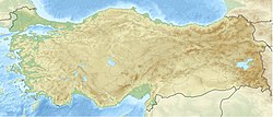
| 座標 | 北緯38度38分 東経42度49分 / 北緯38.633度 東経42.817度座標: 北緯38度38分 東経42度49分 / 北緯38.633度 東経42.817度 |
| 種類 | 塩湖 |
| 主な流入 | Karasu, Hoşap, Güzelsu, Bendimahi, Zilan, Yeniköprü[1] |
| 主な流出 | 無し |
| 集水域面積 | 12,500 km2 (4,800 sq mi)[1] |
| 国 | トルコ |
| 最長 | 119 km (74 mi) |
| 水面積 | 3,755 km2 (1,450 sq mi) |
| 平均水深 | 171 m (561 ft) |
| 最深部 | 451 m (1,480 ft)[2] |
| 水量 | 607 km3 (146 cu mi)[2] |
| 岸全長1 | 430 km (270 mi) |
| 水面標高 | 1,640 m (5,380 ft) |
| 島 |
アクダマル島 Çarpanak島, Adır島(Lim島), Kuş島 (Arter島) |
| 自治体 | ヴァン, タトワン, アフラト, エルジシュ |
| 1 岸の長さは厳密な測定によるものではない。 | |
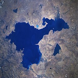
ヴァン湖沿岸には、ウラルトゥ王国(紀元前9世紀-紀元前6世紀)の首都トゥシュパがあった。ヴァン湖内のアクダマル島(Akdamar Island)には、10世紀に建てられたアルメニア使徒教会の教会の遺跡がある。また、東岸のヴァンには1970年代にイランからの鉄道が開通している。ヴァン湖には鉄道連絡船が就航しており、湖の東岸であるヴァンと対岸のタトワンの間を結んでいる。
- ^ a b c Coskun, M.; Musaoğlu, N. (2004) (PDF), Proceedings of the 20th Congress of the International Society for Photogrammetry and Remote Sensing, オリジナルの2008年10月3日時点におけるアーカイブ。
- ^ a b c d e Degens, E.T.; Wong, H.K.; Kempe, S.; Kurtman, F. (June 1984), “A geological study of Lake Van, eastern Turkey”, International Journal of Earth Sciences (Springer) 73 (2): 701–734, doi:10.1007/BF01824978
- ^ Rojnameya AVESTA Archived 2013年9月27日, at the Wayback Machine.. Avestakurd.net. Retrieved on 27 September 2010.
- ^ Kîne em ? – CD 5. Institutkurde.org. Retrieved on 27 September 2010.
- ^ Wong, H.K.; Degens, E.T. (1978), “The bathymetry of Lake Van, eastern Turkey”, Geology of Lake Van, Ankara: General Directorate of Mineral Research and Exploration, pp. 6–10
- ^ Tomonaga, Yama; Brennwald, Matthias S.; Kipfer, Rolf (2007) (PDF), Spatial variability in the release of terrigenic He from the sediments of Lake Van (Turkey), 4th Mini Conference on Noble Gases in the Hydrosphere and in Natural Gas Reservoirs, doi:10.2312/GFZ.mga.045
- ^ Sari, Mustafa (2008), “Threatened fishes of the world: Chalcalburnus tarichi (Pallas 1811) (Cyprinidae) living in the highly alkaline Lake Van, Turkey”, Environmental Biology of Fishes (Springer Netherlands) 81 (1): 21–23, doi:10.1007/s10641-006-9154-9.
- ^ Landmann, Günter; Reimera, Andreas; Lemcke, Gerry; Kempe, Stephan (June 1996), “Dating Late Glacial abrupt climate changes in the 14,570 yr long continuous varve record of Lake Van, Turkey”, Palaeogeography, Palaeoclimatology, Palaeoecology (Elsevier Science B.V.) 122 (1–4): 107–118, doi:10.1016/0031-0182(95)00101-8
- ^ “Ancient Ruins Discovered Under Lake in Turkey” (英語). History. nationalgeographic (2017年11月15日). 2022年9月7日閲覧。
固有名詞の分類
- ヴァン湖のページへのリンク


