ヴァン湖
出典: フリー百科事典『ウィキペディア(Wikipedia)』 (2023/09/11 21:05 UTC 版)
地質学

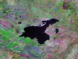
湖の流出は更新世にネムルト山の溶岩流が西方のムシュ平原への流れを塞いだことにより止まっている。現在の休火山では、ネムルト山が湖の西岸を占め、北岸では別の成層火山であるシュプハン山が占めている。
湖の水位はしばしば大きく変動している。オズワルド(1901年、"Geology of Armenia")によれば、タトワン付近では現在の湖面より高い位置の隆起海岸や近年水没した木々もある。1980年代初頭のDegensらの研究では、約18,000年前の氷河期の間は現在より水面が72メートル (236 ft)高かったことが判明した。約9,500年前には劇的な水位の低下があり、現在より300メートル (980 ft)以下の水位となった。続いて、約6,500年前には水位の劇的な上昇が起こっている[2]。
最近でも小さな水位の変動が起きている。1990年代には少なくとも3 m上昇し多くの農地が水没した。2004年までの10年間では約2 m上昇している[1]。
ヴァン湖には周囲の平野と渓谷の浸食による大量の堆積物と、時々発生する隣接する火山の噴火による火山灰が沈殿している。この堆積物の層は厚さが400メートル (1,300 ft)以上と推測され、層状堆積物のボーリングコアに気候学者と火山学者が興味を示している。
1989年と1990年に、ハンブルク大学のステファン・ケンペ博士(現在はダルムシュタット工科大学の教授)率いる地質学者の国際チームにより、最大446 m (1,463 ft)までの深さから堆積物コア10個を回収した。これらのコアは堆積物の最初の数メートル貫いただけであったが、これらは最大14,570年分のBPのプロキシ気候データを与えるのに十分な年層を提供した[8]。

- ^ a b c Coskun, M.; Musaoğlu, N. (2004) (PDF), Proceedings of the 20th Congress of the International Society for Photogrammetry and Remote Sensing, オリジナルの2008年10月3日時点におけるアーカイブ。
- ^ a b c d e Degens, E.T.; Wong, H.K.; Kempe, S.; Kurtman, F. (June 1984), “A geological study of Lake Van, eastern Turkey”, International Journal of Earth Sciences (Springer) 73 (2): 701–734, doi:10.1007/BF01824978
- ^ Rojnameya AVESTA Archived 2013年9月27日, at the Wayback Machine.. Avestakurd.net. Retrieved on 27 September 2010.
- ^ Kîne em ? – CD 5. Institutkurde.org. Retrieved on 27 September 2010.
- ^ Wong, H.K.; Degens, E.T. (1978), “The bathymetry of Lake Van, eastern Turkey”, Geology of Lake Van, Ankara: General Directorate of Mineral Research and Exploration, pp. 6–10
- ^ Tomonaga, Yama; Brennwald, Matthias S.; Kipfer, Rolf (2007) (PDF), Spatial variability in the release of terrigenic He from the sediments of Lake Van (Turkey), 4th Mini Conference on Noble Gases in the Hydrosphere and in Natural Gas Reservoirs, doi:10.2312/GFZ.mga.045
- ^ Sari, Mustafa (2008), “Threatened fishes of the world: Chalcalburnus tarichi (Pallas 1811) (Cyprinidae) living in the highly alkaline Lake Van, Turkey”, Environmental Biology of Fishes (Springer Netherlands) 81 (1): 21–23, doi:10.1007/s10641-006-9154-9.
- ^ Landmann, Günter; Reimera, Andreas; Lemcke, Gerry; Kempe, Stephan (June 1996), “Dating Late Glacial abrupt climate changes in the 14,570 yr long continuous varve record of Lake Van, Turkey”, Palaeogeography, Palaeoclimatology, Palaeoecology (Elsevier Science B.V.) 122 (1–4): 107–118, doi:10.1016/0031-0182(95)00101-8
- ^ “Ancient Ruins Discovered Under Lake in Turkey” (英語). History. nationalgeographic (2017年11月15日). 2022年9月7日閲覧。
固有名詞の分類
- ヴァン湖のページへのリンク