Bata blast: Satellite images show Equatorial Guinea destruction

 Satellite image ©2021 Maxar Technologies
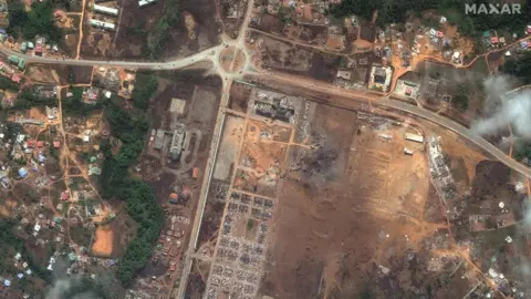
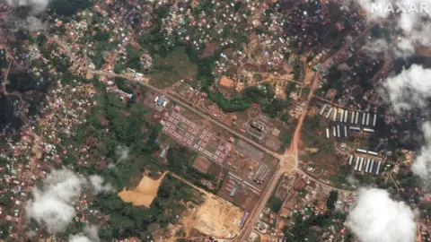
New satellite images reveal the extent of destruction in Equatorial Guinea's main city Bata following explosions at a munitions depot on Sunday.
The official death toll has now reached 105, with at least 600 injured.
Rights groups say the casualty figures could be significantly higher and have called for an independent investigation, with questions being asked about why stockpiles of explosives were being stored in a populated area.
"Based on the number of bodies pulled from the rubble" says Human Rights Watch citing local observers, "the actual number of victims is much higher."
The extent of the damage
Images captured before and after the event show the scale of the explosion.
 Satellite image ©2021 Maxar Technologies
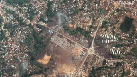 Satellite image ©2021 Maxar Technologies
Buildings inside the barracks were destroyed and people's homes in the surrounding area were also affected. Green spaces circling the army complex were obliterated.
Analysing satellite imagery over the past two decades, it's possible to see how the population rapidly expanded around the barracks.
When the complex was being built in 2004, it can seen on Google Earth surrounded by forest. Just under two decades later, the city has rapidly expanded into this area.
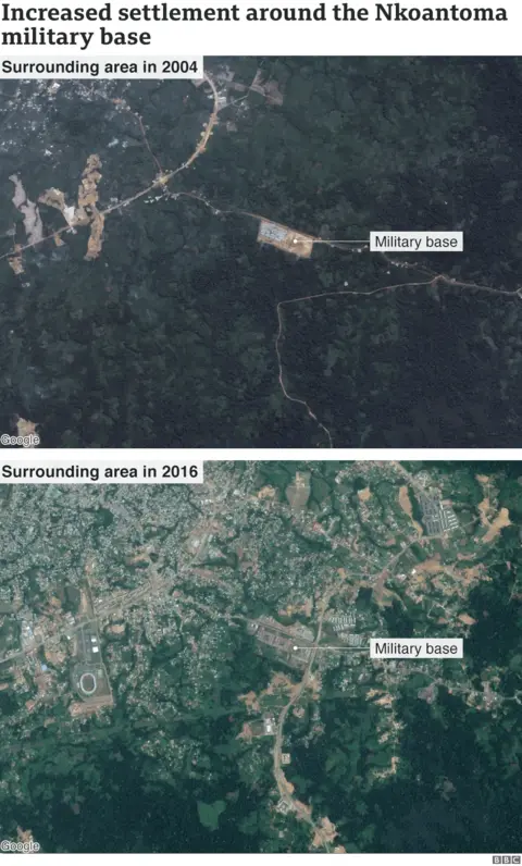
"If you are a responsible government, you do not have a military barracks where bombs are going to be handled in the middle of a city. You don't have families living in that area," Tutu Alicante, a human rights lawyer, told the BBC.
What was the cause?
President Obiang Nguema said the base had "caught fire due to neighbouring farmers clearing land by setting it alight, leading to the explosion".
The president also blamed the "negligence" of the team responsible for guarding the stores of dynamite and explosives.
"Unverified accounts circulating in the country allege the fire was started by soldiers ordered to burn brush and that it then spread to the armoury, or that it was started during training on the use of explosives gone awry," said Human Rights Watch.
A cluster of fires were detected around the location of the barracks at 14:00 local time (13:00 GMT) on 7 March using Nasa satellites.
This is around the same time of the explosions, but it's not possible to identify if these fires were the cause of the explosion or the result of it.
The location of the blast
The explosion happened on the south-east periphery of the city.
Videos shared on social media showed a huge plume of smoke visible from the city centre.
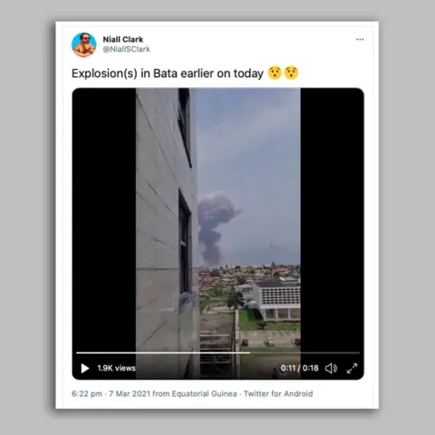
One angle, filmed from a hotel located near the coastline, captured the aftermath of the explosion from about 7km (4 miles) away.
Footage was also captured on the ground in the roads surrounding the barracks which showed extensive destruction of buildings in the military complex and in the surrounding area. Many people - men, women and children - were seen fleeing the area.
"Most military barracks in Equatorial Guinea tend to house not just the soldiers themselves but also their family members," said Mr Alicante.
"What we do know from the government is that supposedly there were some workshops about - buildings where there were bombs being defused, and that might have led to the accident."
Are explosions becoming more common?
Following the explosions, questions are being asked of the government about the management of explosives.
There are also concerns about the debris left over from such events. Social media users are posing with projectiles which have been scattered nearby.
The Small Arms Survey based in Switzerland compiles data on the number of unplanned explosions at munitions sites around the world.
Between 2010 and 2019, it recorded 242 incidents globally.
These included:
- Africa - 39
- Americas - 16
- Asia - 116
- Europe - 70
- Oceania - 1
Five countries accounted for a third of all incidents: the Russian Federation (28), Syria (20), Iraq (15), Ukraine (15), and Yemen (13), says the survey.
"Western Asia, a sub-region characterised by intensifying armed conflicts, was the site of 38% of the total of the globally documented unplanned explosions at munitions sites (UEMS) in the 2015-19 period, and accounted for most of the recent growth in UEMS, which were also on the rise in Western Africa," it adds.
The most common causes of unplanned explosions were "failure to take into account external and environmental influences and events", and "handling errors and inappropriate working practices".