Hidalgo County, in South Texas, is bordered by Cameron County on the east, Brooks County on the north, Starr County on the west, and Mexico on the south. The county seat, Edinburg, is at the junction of U.S. highways 107 and 281. The center point of the county is at 26°23' north latitude and 98°10' west longitude. Other communities of note in Hidalgo County are McAllen, Weslaco, Mission, Peñitas, and San Juan. Hidalgo County comprises 1,596 square miles of the Rio Grande delta. Its elevations range from forty to 200 feet. The northern part of the county has sandy and light loamy soils over deep reddish or mottled, clayey subsoils. In some areas limestone lies within forty inches of the surface. The southern part of the county has moderately deep to deep loamy surfaces over clayey subsoils. Along the Rio Grande brown to red clays occur. Hidalgo County is in the South Texas Plains vegetation area, which features grasses, mesquite, live oaks, and chaparral. Native plants, reduced in recent years by extensive farming, include chapote, guayacan, ebony, huisache, Brazilwood, and yucca. Natural resources include caliche, sand, gravel, oil, and gas. The climate is subtropical and subhumid. Temperatures range from an average low of 47° F in January to an average high to 96° in July; the average annual temperature is 73°. Rainfall averages twenty-three inches a year, and the growing season lasts for 320 days of the year.
Indians have called the area home for 11,000 years. Artifacts dating to the Archaic Period indicate that inhabitants of the region were hunters and gatherers who practised no agriculture and kept no domestic animals except a few dogs. Subsequently, some forms of agriculture, such as raising maize, were introduced. Several major linguistic groups called the lower Rio Grande valley home, including Coahuilteco and Karankawa. The Coahuiltecans in the future county hunted a wide variety of animals, fished, gathered berries, fruits, and roots, and used mountain laurel for its narcotic effects. The Lipan Apaches, having been forced out of Colorado and New Mexico by the Comanches, entered Texas in the 1700s and gained control of South Texas by 1775. The Comanches followed them and arrived in South Texas in the early nineteenth century.
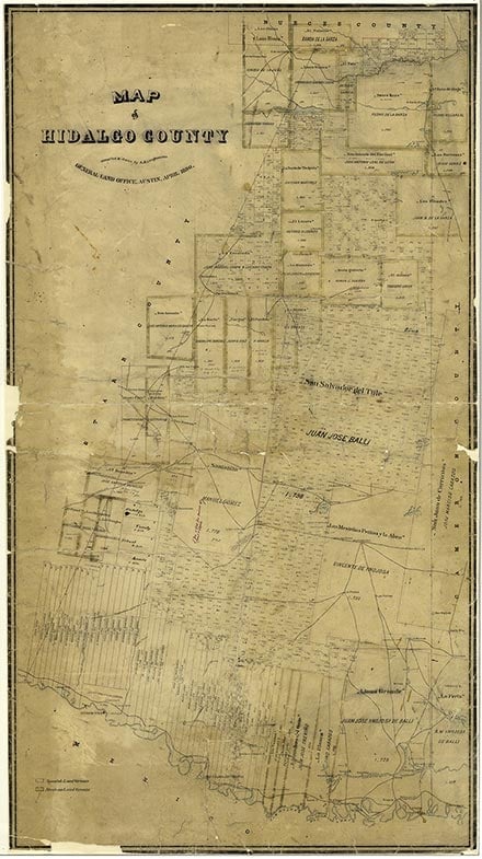
Some historians surmise that Álvar Núñez Cabeza de Vaca traveled through the area after his 1528 shipwreck. In August 1638 Jacinto García de Sepulveda crossed the Rio Grande into the area at the site of Mier in search of Dutch sailors reported on the Texas coast. In 1687 the second expedition of Alonso De León in search of Fort St. Louis also followed the river route. In 1747 Miguel de la Garza Falcón reconnoitered the northern bank of the river in search of suitable land to establish a settlement. He found the land unsuitable even for stock raising and condemned it as uninhabitable. Despite his judgment, the area again drew the attention of the Spanish crown, and in 1749 José de Escandón was assigned the task of colonizing the area. He established four towns on the southern banks of the Rio Grande including Reynosa (1749), which was originally located across the river from the site of present-day Peñitas. He founded Camargo, Mier, and Revilla (now Guerrero) in 1749, 1750, and 1752 respectively. Settlers from these colonies later crossed the Rio Grande and settled the northern banks of the river. About eighty porciones in about nineteen grants were issued in the future Hidalgo County by the Spanish and Mexican governments. Colonization was left in the hands of the grantees, who established settlements along the river as well as in the northern reaches of the future county. A settlement called La Habitación, also known as Rancho San Luis or San Luisito, was established north of the river at the site of present-day Hidalgo, Texas, in 1774. Because the land was suitable for cattle and sheep raising the grantees turned to ranching with great success. Among the first settlers was Juan José Ynojosa de Ballí, who was issued the Llano Grande grant on May 29, 1790. Another successful rancher was José Manuel Gómez, who received the Santa Anita grant in 1798. In 1797 he established the Santa Anita Ranch, which was still in operation in 1995 under the name McAllen Ranch. Most of the other grantees also managed to settle their land and become successful ranchers.
By 1836 area farmers had a thriving economic base that allowed them to export their cattle and cattle by-products into Mexico. Goods were moved by wagon and mule trains, whose owners were so organized that they kept boats off the Rio Grande until after 1840. With the outbreak of the Texas Revolution the area became disputed territory, Mexico considered it part of Tamaulipas, and Texas claimed it as part of its southern border. During the Mexican War, Zachary Taylor laid out the Old Military Road to supply his men in northern Mexico. In 1849 the area became a popular stopping point for goldseekers from the United States on their way to California. The military road had become part of the Gila Route to the West Coast. By 1850 about thirty-nine ranches were in operation in what later became Hidalgo County . Mexico was the main market for goods from the area. Residents grew a variety of fruits and vegetables, including squash, citrus fruit, and corn. After 1849 the Oblates of Mary Immaculate periodically visited the ranches between Brownsville and Laredo. Hidalgo County was part of the disputed territory during the Mexican War. After the Treaty of Guadalupe Hidalgo of 1848 the area became part of San Patricio County. In the same year the region was further subdivided and became part of Cameron County.
Hidalgo County was formed in 1852 and named for Miguel Hidalgo y Costilla, who gave the "cry for Mexican independence" from Spanish rule. By 1852 the county had between forty and forty-five ranches. As land was parceled out from one generation to the next the ranches located along the river developed into villages. In this way, ranches gave rise to the communities of La Habitación, Relampago, and Peñitas. Ranches away from the river included Laguna Seca Ranch, founded in 1867, Mora Relámpago Ranch (1875), and San Manuel Ranch (1876). Generally, inhabitants of the area, especially those in the north, made a living by stock raising, while those along the river were involved in transportation, agriculture, and trade with Mexico. In 1852 La Habitación was renamed Edinburgh and made county seat. The first county court convened on September 2, 1852, and as its first act issued licences to ferries at Hidalgo, San Luis, Peñitas, and Las Cuevas. José M. J. Carbajal was an early court reporter. County residents were isolated from each other, however, and from the population center of Brownsville in neighboring Cameron County. Because of their sense of neglect by state and federal governments, residents adopted the name "Republic of Hidalgo." Isolation and ineffective law enforcement led to general chaos and lawlessness, mostly in the form of cattle raids and shootouts. The "Cortina Wars" also caused disturbances, especially when Juan Nepomuceno Cortina, on his way to a robbery, was intercepted by a force of Texas Rangers. The skirmish known as the battle of La Bolsa occurred on February 4, 1860, in El Zacatal, south of Progreso in southeast Hidalgo County. Despite difficulties, ranching dominated the economy in 1860, when 10,695 cattle and 3,330 sheep were counted; the latter produced 10,900 pounds of wool. Rustling also thrived. As early as December 28, 1862, armed Mexican bandits crossed into Los Ebanos, captured a Confederate wagontrain, and killed three teamsters. At other times Mexican cattle rustlers would cross into Texas with the purpose of stealing as many cattle as possible. Hidalgo County did not prosper from the Civil War as did Cameron County, but instead found itself battling cattle rustlers, who were joined by both Union and Confederate deserters. In 1870 rustlers were attracted to a county with 18,141 cattle and 11,270 sheep and a population of only 2,387. From 1872 to 1875 Sheriff Alex J. Leo repeatedly wired Washington requesting troops to curtail cattle rustling and end the "Cattle Wars," but his efforts were in vain. On April 2, 1875, Capt. Leander H. McNelly and a band of Texas Rangers arrived to help.
Hidalgo County had become a haven for outlaws from both sides of the river by the middle of the nineteenth century. Politically it had become a battleground, as various groups vied for dominance of county politics. Party affiliations, especially with the Reds and Blues, were firmly entrenched by 1869. Members of the Democratic party, known as the Reds, included Thaddeus Rhodes, Ben Kidder, Pete Champion, W. P. Dougherty and James Dougherty. The Republican party members, the Blues, included John McAllen, Jesse Bennett, and Dr. Alexander M. Headley. The Reds ruled the county for most of the last third of the nineteenth century. Their ineffective government was blamed for the county's having eight sheriffs between 1869 and 1876. It was alleged that the Reds kept control of the county by using the pachanga or block vote, which entailed rounding up men, filling them with food and liquor, and paying their poll tax. In Hidalgo County, Martin "Big Drunk" Norgraves, who served as first county clerk, was credited as organizer of block voting. By 1880 the population was 4,347, and all except women and the 114 African Americans were fair game for the parties looking for votes. Not until 1882, when John Closner was elected deputy sheriff, was control over cattle rustlers achieved. Closner became sheriff in 1890 and shortly afterward, under the protection of James B. Wells, became the county's political boss. During his rule he brought peace to the county and was seen as such an effective leader that he was nicknamed the "father" of Hidalgo County. In the process, however, he made many enemies. During the 1890s his rivals tried to have him assassinated twice and brought a ranger investigation against him. He was accused of mistreating prisoners, and he later admitted that he could have gone a little too far in pressuring suspects to confess to crimes. Though Closner's Reds were effective in bringing law and order to the county, the rivalry with the Blues did not abate. It came to a head in August 1890, when the Blues set up their polls and judges while the Reds held elections. This effectively gave the county two sets of officials. The Blues wanted to stop the Reds' use of the pachanga, which gave undocumented aliens access to the polls. Consequently, Dr. Headley and a company of 150 Blues took over Edinburgh and ruled the for several days under the moniker "Independent Republic of Hidalgo." United States officials ended Headley's "republic" when he attempted to collect customs at the border.
Despite political turmoil and cattle rustling, the county population grew to 6,534 by 1890. Ranching reached its peak that year with 71,176 cattle; 20,906 sheep gave 41,074 pounds of wool. The Garza War came to an end in 1891, when Catarino Erasmo Garza and his men were defeated at La Joya in southwest Hidalgo County. In 1886 Edinburgh was washed away by a severe flood, after which it was moved to another flood-prone site about two miles north of the river. The county population was estimated at 6,837 in 1900. The Hidalgo Advance, the county's first newspaper, went into publication in March 1903. It was published for the sole purpose of advertising the county and attracting a railroad. When it arrived in 1904, the St. Louis, Brownsville and Mexico Railway made a big difference. In 1903 land sold for twenty-five cents an acre, but by 1906 it was selling at fifty dollars an acre, and by 1910 the price had increased to as much as $300 an acre. Farming in Hidalgo County was not practiced on a large scale until the latter part of the nineteenth century. Citrus fruits were among the first products cultivated. By 1878 Carlota Vela at the Laguna Seca Ranch had a small orange grove that was known for the quality of its fruit. Later the primary crops were cotton and sugarcane planted on large plantations for export. The first attempt at growing cane on a large scale was made in 1883 by John Closner, who established a plantation and mill near the site of present-day Pharr. Attempts to irrigate rice were unsuccessful, but citrus fruits and vegetables were produced on a commercial basis starting around 1907, when W. A. Fitch planted a commercial-scale grapefruit orchard near Mercedes. Chapin, a community established in 1908, was soon made county seat and renamed Edinburg. The old county seat, Edinburgh, was moved away from the river and renamed Hidalgo. With the introduction of the railroad and the influx of settlers wishing to establish farms during the first decade of the twentieth century, the county's economic base shifted toward farming. The primary crops were corn and cotton. The population was estimated at 13,728 in 1910. In 1911 the San Benito and Rio Grande Valley Railway made junction with the St. Louis, Brownsville and Mexico Railway at San Benito. The Texas and New Orleans built into the Valley in 1927.
During the first decade of the twentieth century Closner and his Democratic machine ran unopposed, and nominees for district and state offices received 90 percent of the votes. In 1914 the county had only 700 Anglo-American farmers who had paid their poll tax, as opposed to the 1,200 Hispanics that the Democratic machine could mobilize. In 1914 the Good Government League was established after Judge James H. Edwards was ousted by the Closner regime. The league was made up exclusively of Anglo farmers, businessmen, and professionals who supported Edwards and promised to "clean up" Hidalgo County politics. Because the league's intentions included disfranchising Hispanics, the campaign to change the system took on strong racial overtones. The Closner regime was perceived as pandering to Hispanics, although fewer than one-fourth of government positions were held by them. Racial and social tensions increased between old-timers, mainly ranchers, and newcomers, mainly farmers. Closner's reign ended in 1918, when an audit revealed that as county treasurer he had misappropriated $150,000 from the county, drainage districts, and the school district. Sheriff Anderson Y. Baker then took control over the Democratic machine and maintained it for twelve years, through voter manipulation, election fraud, and large-scale graft. Because of the machine's shenanigans the Weslaco ballot box was thrown out during the 1928 county election. In the resulting "Hidalgo County Rebellion" the citizens of Weslaco armed themselves against the Mexican voters, whom they considered pawns of the machine. Weslaco's Anglo voters, all new farmers to the area and opposed to the regime, asked for and got a federal investigation. The investigation not only hurt the machine but further marginalized Hispanic voters, who were scared away from the polls. In 1929, in yet another attempt to oust the remnants of boss rule, the Good Government League, headed by Charles H. Pease, led a successful struggle to remove county government from control of a faction that monopolized irrigation projects and oil. Thus Wells and Closner's political machine, which ran Hidalgo County and caused its economic boom, was in the end ousted by the settlers it attracted.
In 1920 the population was 38,110, more than double what it had been in 1910, and the number of farms had increased to 1,727, seven times the number of farms in 1890. John H. Shary, who became a successful land developer and promoter, arrived in Hidalgo County in 1912. Shary, who developed the citrus industry, was selling his grapefruit by 1919. In 1924 a regional Texas Agricultural Experiment Station was established in Weslaco. Thriving towns sprang up across the southern part of the county east to west along U.S. Highway 83, which by 1930 was described as the "longest main street in the world." Race relations in Hidalgo County during the nineteenth century had been fairly amicable even as the number of Anglo-Americans moving to the area increased. With the advent of the railroad Hidalgo County became a magnet for settlers from the Midwest and the East. These settlers, unlike their ranching predecessors, were not willing to adapt to Hispanic culture and considered themselves superior to Mexican Americans. Consequently, all the new towns that developed along the St. Louis, Brownsville and Mexico Railway during the first twenty years of the twentieth century were fully segregated. The two best known for their segregation were Weslaco and McAllen, but most of the other towns along U.S. 83 were segregated, unlike the old towns of Hidalgo, Peñitas, and Relampago. The wall between the races became increasingly impenetrable. Between 1912 and 1915 border raids claimed at least thirty Anglo lives and several hundred Mexican lives, converted the area into a combat zone, and brought settlement to a halt. Though the raiders disrupted lives and stole cattle, law-enforcement officers were also accused of excessive violence and unjust practices. Toward the end of the 1920s, however, settlement resumed and segregation had become the norm. Because all the new towns were fully segregated it was impossible for Hispanic children to get an equal education. Inexperienced teachers were assigned to teach at the Mexican schools, which were usually overcrowded and ill equipped. There were no Mexican high schools because Hispanics were not expected to advance beyond elementary school. This deprivation led to self-perpetuating poverty as uneducated (and therefore poor) parents removed their children from school so that they could help support the family. In 1930 the county's population was estimated at 77,004, of which 41,522 individuals were identified as "Mexican."
By 1930 the conversion of the economy to truck farming was complete. That year there were only 34,505 cattle, and the number of farms had increased to 4,321, more than double the number in 1920. The primary crops were cotton, planted on 131,884 acres, and corn, planted on 14,658 acres. Stock farming and ranching continued mainly in the northern part of the county, where cattle, sheep, and poultry were the main livestock. Despite the Great Depression, the county's population increased to 106,059 in 1940. The number of residents always fluctuated, however, during any given year because migrant farmworkers and winter Texans or "snowbirds" came and went. The first producing oil well in the county was brought in on September 18, 1934, by Otto C. Woods. The oil and gas industry soon became important in the county. With the increase in population the number of farms grew by 1940 to 5,094. Hidalgo County got its first military base in 1941, when Moore Air Field was built twelve miles northwest of Mission. The field was operated by the United States Army Air Force during World War II and was named for Lt. Frank Murchison Moore, a Texan. That year the county's sixty-two manufacturing establishments produced $6,502,129 in products. The population was estimated at 160,446 in 1950. By that year the county had 5,314 farms, and citrus fruit production had become the most important industry. That year's harvest yielded 3,093,792 boxes of oranges and 169,245 tons of grapefruit. Cotton production was 197,267 bales, and corn production was 72,495 bushels. The population of Hidalgo County was estimated at 180,904 in 1960. By 1967 the county had produced twenty million barrels of oil. In 1969 an estimated $50 million came from Hidalgo County's winter vegetables, citrus fruit, and cotton. That year the number of farms had declined to 4,124, a decrease attributable to the increase in farming corporations. By 1970 the population of Hidalgo County had reached 181,533. The civil-rights movement that had swept the country during the 1960s brought increased participation of Hispanics in Hidalgo County politics, though problems related to race were not over, as the "Pharr Police Riot" of 1971 illustrates (seePHARR, TEXAS). In Donna, migrant farmworkers' children were sent to a separate school until the late 1970s. Colonias started cropping up around the county as more Mexicans crossed the Rio Grande in an attempt to improve their lives, and some local businessmen exploited the recent migrants by selling them useless land. The immigration increased throughout the 1970s. The population doubled between 1970 and 1977, to an estimated 232,300. By 1978 Hidalgo County was averaging $188 million in annual farm income, 90 percent of which came from cotton, corn, citrus fruit, sugarcane, and grain. Also by that year the average annual income from mineral production, including oil and gas, was $65 million. The peso devaluation of 1976 did not have an immediate effect on the economy of the Rio Grande valley. Not until the mid-1980s did area merchants who catered to Mexican nationals began to experience the negative effects of the several devaluations that occurred in that decade. Clothiers, jewelers, car dealers, and some real estate agents were hurt; agribusiness, ranching, and the oil industry suffered less.
In 1980 the population was estimated at 283,229, including 15,868 retired workers. The industries with the most workers were agribusiness, tourism, oil and gas field servicing, construction, frozen food processing and canning, meat packing, and soft drink bottling, industries which earned an aggregate of $1,575,879,000. In 1982 Hidalgo County had 171 manufacturers with 7,100 employees and products valued at $211.9 million. In 1982 Hidalgo County was ranked sixty-fourth among all United States counties in the highest birth rate and twelfth in highest percent of Hispanic-origin residents. The county has never experienced a decrease in population. Its residents numbered 383,545 in 1990. Hispanics, Germans, and Anglo-Americans are the three largest ethnic groups. But the labor force that made Hidalgo County a prosperous agricultural region also made it the poorest in the nation. The McAllen-Edinburg-Mission metropolitan area had the lowest per capita income (estimated at $7,001) in the United States in 1987. Furthermore, Hidalgo County had the state's highest unemployment rate, and county government was so underfunded that its independent health-care program ran out of money halfway through the fiscal year. Nevertheless, corporations were doing well, and by 1988 more than $1 billion a year in goods passed through the foreign trade zone located south of McAllen in south central Hidalgo County. After its warehouses filled up that year, the foreign trade zone had to turn away tenants. In 1988 Hidalgo County hosted 80,000 "winter Texans." Retail sales rose 22.6 percent that year. Little profit found its way to the poorest people, however, a fact reflected in the standard of living of colonia dwellers, of whom an estimated 52,000 lived in 366 colonias in 1986. The problems of inadequate water supply and substandard housing were rife among colonia residents, many of whom were migrant farmworkers. It was hoped that in the 1990s part of the problem would be solved by new trade and opportunities for employment brought by the North American Free Trade Agreement. Because of its proximity to Mexico, Hidalgo County was also a favored entry point for drug smugglers. In 1992 it was discovered that an unusually high number of children born in the county were being born with anencephaly, a neural birth defect. As of 1989, twenty-seven out of every 10,000 babies born to Hispanic women in the area had neural birth defects, and this situation had not improved by 1992, when women of child-bearing age were told to consume folic acid to prevent further defects while various organizations studied the problem.
Inhabitants of Hidalgo County consistently voted Democratic in presidential elections from 1852 to 2000; the only exceptions occurred in 1860, when Constitutional Union candidate John Bell carried the area, and in 1928, 1952, 1956, and 1972, when Republicans did. In 2004, however, Republican George W. Bush took the county with a comfortable margin of victory.
The U.S. census counted 831,073 people living in Hidalgo County in 2014. About 91 percent were Hispanic and 7.3 percent were Anglo. Of residents age twenty-five and older, 51 percent had completed high school, and 13 percent had college degrees. In the early twenty-first century food processing and other agribusinesses, tourism and mineral operations were important elements of the local economy. In 2002 the county had 2,104 farms and ranches covering 593,158 acres, 68 percent of which were devoted to crops and 28 percent to pasture. That year farmers and ranchers in the area earned $202,073,000; crop sales accounted for $182,431,000 of the total. Sugar cane, vegetables, grain, citrus, cotton, and cattle were the chief agricultural products. More than 2,777,000 barrels of oil, and 234,486,500 thousand cubic feet of gas well gas, were produced in the county in 2004; by the end of that year 110,100,000 barrels of petroleum had been taken from county lands since 1934.
Edinburg (population 85,456) is the county’s seat of government and the home of the University of Texas-Pan American. Other communities include McAllen (138,356), Mission (81,581), and Pharr (74,344). Recreational facilities in the county include the Hidalgo County Historical Corridor which spans the southern portion of the county and various parks and wildlife refuges, including Santa Ana National Wildlife Refuge and the Las Palomas Wildlife Management area. Special events include the Citrus Fiesta, the Weslaco Sugarfest, and the Rio Grande Valley Stock Show. Fishing and hunting are also available throughout the year. The county has several museums and historic homes. La Lomita Mission is located in Mission, and the Virgen de San Juan del Valle Shrine is in San Juan. See alsoAGRICULTURE, BOSS RULE.
Is history important to you?
We need your support because we are a non-profit that relies upon contributions from our community in order to record and preserve the history of our state. Every dollar helps.
James Lewellyn Allhands, Gringo Builders (Joplin, Missouri, Dallas, Texas, 1931). Evan Anders, Boss Rule in South Texas: The Progressive Era (Austin: University of Texas Press, 1982). Guide to Spanish and Mexican Land Grants in South Texas (Austin: Texas General Land Office, 1988). Thomas Hester, Digging into South Texas Prehistory: A Guide for Amateur Archaeologists (San Antonio: Corona Press, 1980). Hidalgo County Centennial Corporation, The Centennial Celebration of the Organization of Hidalgo County in Texas (Mission, Texas: Times Publishing Company, 1952). David Montejano, Anglos and Mexicans in the Making of Texas, 1836–1986 (Austin: University of Texas Press, 1987). W. Clyde Norris, History of Hidalgo County (M.A. thesis, Texas College of Arts and Industries, 1924). J. Lee and Lillian J. Stambaugh, The Lower Rio Grande Valley of Texas (San Antonio: Naylor, 1954). Vertical Files, Dolph Briscoe Center for American History, University of Texas at Austin. David Martell Vigness, The Lower Rio Grande Valley: 1836–1846 (M.A. thesis, University of Texas, 1948).
The following, adapted from the Chicago Manual of Style, 15th edition, is the preferred citation for this entry.
Alicia A. Garza,
“Hidalgo County,”
Handbook of Texas Online,
accessed May 01, 2024,
https://www.tshaonline.org/handbook/entries/hidalgo-county.
Published by the Texas State Historical Association.
TID:
HCH14
All copyrighted materials included within the Handbook of Texas Online are in accordance with Title 17 U.S.C. Section 107 related to Copyright and “Fair Use” for Non-Profit educational institutions, which permits the Texas State Historical Association (TSHA), to utilize copyrighted materials to further scholarship, education, and inform the public. The TSHA makes every effort to conform to the principles of fair use and to comply with copyright law.
If you wish to use copyrighted material from this site for purposes of your own that go beyond fair use, you must obtain permission from the copyright owner.