
ファイル:Map of Constantinople (1422) by Florentine cartographer Cristoforo Buondelmonte.jpg
このプレビューのサイズ: 476 × 600 ピクセル。 その他の解像度: 190 × 240 ピクセル | 592 × 746 ピクセル。
元のファイル (592 × 746 ピクセル、ファイルサイズ: 838キロバイト、MIME タイプ: image/jpeg)
ウィキメディア・コモンズのファイルページにある説明を、以下に表示します。
|
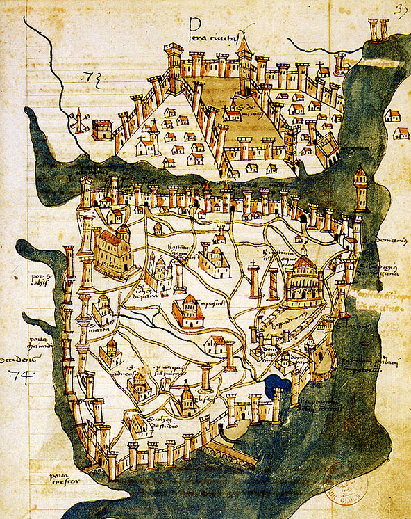
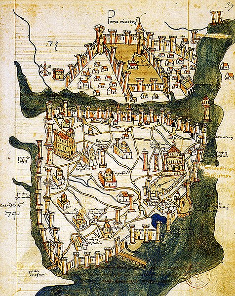
| 解説 | Map of Constantinople (a small part of modern Istanbul), called "Historic Peninsula", Tarihi Yarımada en Turkish) designed in 1422 by Florentine cartographer Cristoforo Buondelmonti (Description des îles de l'archipel, Bibliothèque nationale, Paris) is the oldest surviving map of the city, and the only surviving map which predates the Turkish conquest of Constantinople in 1453. | ||||
| 日付 | |||||
| 原典 | Liber insularum Archipelagi (1824), version available at the Bibliothèque nationale de France, Paris | ||||
| 作者 | Cristoforo Buondelmonti | ||||
| 許可 (ファイルの再利用) |
|
||||
| その他のバージョン |
|
||||

_by_Florentine_cartographer_Cristoforo_Buondelmonte.jpg?uselang=ja)
_by_Florentine_cartographer_Cristoforo_Buondelmonte.jpg?uselang=ja)
_by_Florentine_cartographer_Cristoforo_Buondelmonte.jpg?uselang=ja&action=history)
_by_Florentine_cartographer_Cristoforo_Buondelmonte.jpg)
ファイルの履歴
過去の版のファイルを表示するには、その版の日時をクリックしてください。
| 日付と時刻 | サムネイル | 寸法 | 利用者 | コメント | |
|---|---|---|---|---|---|
| 現在の版 | 2007年6月25日 (月) 10:24 | | 592 × 746 (838キロバイト) | M.K. | {{Information |Description=Map of Constantinople (1422) by Florentine cartographer Cristoforo Buondelmonte (''Description des îles de l'archipel'', Bibliothèque nationale, Paris) is the oldest surviving map of the city, and the only surviving ma |
ファイルの使用状況
以下の 3 ページがこのファイルを使用しています:
グローバルなファイル使用状況
以下に挙げる他のウィキがこの画像を使っています:
- ar.wikipedia.org での使用状況
- az.wikipedia.org での使用状況
- ba.wikipedia.org での使用状況
- bg.wikipedia.org での使用状況
- ca.wikipedia.org での使用状況
- ce.wikipedia.org での使用状況
- cs.wikipedia.org での使用状況
- de.wikipedia.org での使用状況
- el.wikipedia.org での使用状況
- en.wikipedia.org での使用状況
- Bosporus
- Constantinople
- Constantine XI Palaiologos
- John VII Palaiologos
- Walls of Constantinople
- Beyoğlu
- Maiden's Tower
- Siege of Constantinople (1422)
- Siege of Constantinople (1411)
- Template:Did you know nominations/Kontoskalion
- Piyalepaşa, Beyoğlu
- Wikipedia:Main Page history/2019 February 23
- Siege of Constantinople (1394–1402)
- es.wikipedia.org での使用状況
- et.wikipedia.org での使用状況
- eu.wikipedia.org での使用状況
- fa.wikipedia.org での使用状況
- frp.wikipedia.org での使用状況
- fr.wikipedia.org での使用状況
このファイルのグローバル使用状況を表示する。
_by_Florentine_cartographer_Cristoforo_Buondelmonte.jpg)
_by_Florentine_cartographer_Cristoforo_Buondelmonte.jpg)