
ファイル:International E Road Network green.png

このプレビューのサイズ: 800 × 571 ピクセル。 その他の解像度: 320 × 229 ピクセル | 640 × 457 ピクセル。
元のファイル (840 × 600 ピクセル、ファイルサイズ: 38キロバイト、MIME タイプ: image/png)
ウィキメディア・コモンズのファイルページにある説明を、以下に表示します。
|

|
このroad map画像は、ベクターイメージである SVG ファイルとして再作成されるべきです。これにはいくつかの利点があります。詳しくはCommons:Media for cleanupを参照してください。この画像の SVG 形式がすでに利用可能である場合は、アップロードしてください。アップロード後、この画像にあるこのテンプレートを{{Vector version available|新しい画像ファイル名.svg}}テンプレートで置き換えてください。
|
概要
| 解説 |
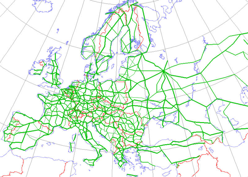
English: Map generated using coastline/boundary data from World Data Bank, and locations from http://www.world-gazetteer.com/. Straight lines connect control cities, no attempt to follow the real road. Roads color has been changed to green.
Deutsch: Diese Karte wurde mit den Küsten- und Grenzverlaufsdaten aus der World Data Bank und mit den Koordinaten aus http://www.world-gazetteer.com/ erstellt. Die Städte sind durch gerade Linien vebunden die nicht unbedingt den realen Straßenverlauf wiedergeben. Die Farbe der Straßen wurde in grün geändert.
Türkçe: Harita oluşturulken sahilyolu ve sınırlar bilgisi Dünya Bilgi Bankası'ndan ve lokasyonlar http://www.world-gazetteer.com/ adlı siteden alınmıştır. Düz çizgiler kontrol şehirlerini bağlar. Yol rengi yeşile değiştirildi. |
| 原典 | http://en.wikipedia.org/wiki/Image:International_E_Road_Network.png |
| 作者 | Kjhskj75 |
ライセンス
| この著作物の著作権者である私は、この著作物における権利を放棄しパブリックドメインとします。これは全世界で適用されます。 一部の国では、これが法的に可能ではない場合があります。その場合は、次のように宣言します。 私は、あらゆる人に対して、法により必要とされている条件を除き、如何なる条件も課すことなく、あらゆる目的のためにこの著作物を使用する権利を与えます。 |
ファイルの履歴
過去の版のファイルを表示するには、その版の日時をクリックしてください。
| 日付と時刻 | サムネイル | 寸法 | 利用者 | コメント | |
|---|---|---|---|---|---|
| 現在の版 | 2008年5月13日 (火) 16:09 | | 840 × 600 (38キロバイト) | Jklamo | Albania update |
| 2007年12月22日 (土) 12:07 |  | 840 × 600 (39キロバイト) | BIL | == Description == {{Information |Description=Map generated using coastline/boundary data from World Data Bank, and locations from www.world-gazetteer.com. Straight lines connect control cities, no attempt to follow the real road. Roads color has been chan | |
| 2007年10月7日 (日) 20:03 |  | 840 × 600 (33キロバイト) | The RedBurn | All e-roads in green. | |
| 2007年10月7日 (日) 19:55 |  | 840 × 600 (34キロバイト) | The RedBurn | {{Information |Description=Map generated using coastline/boundary data from World Data Bank, and locations from www.world-gazetteer.com. Straight lines connect control cities, no attempt to follow the real road. Roads color has been changed to green. |Sou |
ファイルの使用状況
このファイルへは 100 を超える数のページで使用されています。 以下の一覧ではこのファイルを使用している最初の 100 ページのみを表示しています。 完全な一覧も参照してください。
- E001号線
- E002号線
- E003号線
- E004号線
- E005号線
- E006号線
- E007号線
- E008号線
- E009号線
- E010号線
- E011号線
- E012号線
- E013号線
- E014号線
- E015号線
- E016号線
- E017号線
- E018号線
- E019号線
- E05号線
- E101号線
- E105号線
- E10号線
- E136号線
- E15号線
- E231号線
- E232号線
- E233号線
- E25号線
- E29号線
- E30号線
- E35号線
- E401号線
- E402号線
- E422号線
- E441号線
- E45号線
- E471号線
- E501号線
- E502号線
- E511号線
- E512号線
- E531号線
- E532号線
- E551号線
- E55号線
- E571号線
- E572号線
- E574号線
- E576号線
- E577号線
- E578号線
- E592号線
- E601号線
- E602号線
- E603号線
- E604号線
- E606号線
- E607号線
- E60号線
- E611号線
- E612号線
- E651号線
- E65号線
- E671号線
- E673号線
- E711号線
- E712号線
- E713号線
- E714号線
- E717号線
- E75号線
- E772号線
- E773号線
- E803号線
- E804号線
- E805号線
- E80号線
- E821号線
- E840号線
- E841号線
- E842号線
- E843号線
- E844号線
- E846号線
- E847号線
- E848号線
- E85号線
- E881号線
- E901号線
- E902号線
- E90号線
- E931号線
- E932号線
- E951号線
- E952号線
- E95号線
- E961号線
- E962号線
- ヨーロッパの交通
このファイルへのリンク元を更にを表示する。
グローバルなファイル使用状況
以下に挙げる他のウィキがこの画像を使っています:
- ar.wikipedia.org での使用状況
- be.wikipedia.org での使用状況
- bg.wikipedia.org での使用状況
- Европейски път
- Европейски път Е79
- Европейски път Е70
- Европейски път Е80
- Европейски път Е67
- Европейски път Е85
- Европейски път Е851
- Европейски път Е671
- Шаблон:Европейска пътна мрежа
- Европейски път Е81
- Европейски път Е804
- Европейски път Е763
- Европейски път Е762
- Европейски път Е87
- Европейски път Е772
- Европейски път Е83
- Европейски път Е871
- Европейски път Е75
- Европейски път Е773
- Европейски път Е11
- Европейски път Е51
- Европейски път Е761
- Европейски път Е17
- Европейски път Е76
- Европейски път Е82
- Европейски път Е84
- Европейски път Е86
- Европейски път E01
- Европейски път E03
- Европейски път E04
- Европейски път E05
- Европейски път E06
- Европейски път E07
- Европейски път E08
- Европейски път E09
- Европейски път E10
- Европейски път E12
- Европейски път E13
- Европейски път E14
このファイルのグローバル使用状況を表示する。