 Route Editor

| Guide | ♦ | 18 Triplogs | 1 Topic |
details | drive | permit | forecast | route |
stats |
photos | triplogs | topic | location |
| 335 | 18 | 1 |
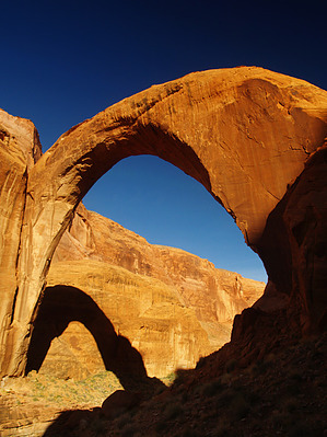
Somewhere over the rainbow... by PaleoRob  Overview Rainbow Bridge is one of the largest natural bridges in the world. It is 290 feet tall and spans Bridge Creek with an almost perfect parabolic arch 275 feet across. First seen by outsiders in the early 20th century, Rainbow Bridge remains one of the most memorable sights in the Four Corners region. Warning The first 8 miles of this trail are totally waterless and generally shadeless. The descent down Yabut (Cha'a') Pass is very steep, shadeless, and treacherous. Redbud Pass requires some easy downclimbing that may require removing packs. The area is very isolated with almost no cell phone reception. Accidents can become very serious very quickly take heed and make appropriate preparations - approach this trail with respect.
In the 1920s Rainbow Lodge was opened to provide a shorter and easier route to the spectacular and recently publicized Rainbow Bridge. The trail was constructed along the western flank of Navajo Mountain up to the lip of Cliff Canyon at Yabut Pass. From there it dropped into Cliff Canyon through perilous switchbacks and then over the man-made Redbud Pass to Bridge Canyon. While business was never brisk, some hardy souls did take the trek via mule down to the bridge and back up. By the 1960s, however, tourists were taking the more popular route to Rainbow Bridge via the Colorado River. In 1961, according to a historic park brochure, the lodge was still operating, but later in the decade the lodge was abandoned and the lodge burned down. Today it stands as a lonely monument to human enterprise and the harshness of the desert. Hike The hike begins at the Rainbow Lodge. It is well cairned and heads roughly northward towards the Utah border along the flank of Navajo Mountain. After winding your easy way across the pinon-juniper forest, you come to the first of several canyons you must cross - First Canyon. While not as deep as other canyons, First sets you up for what is to come and starts your heart rate rising. The trail is well maintained, and as it climbs out of the canyon and crosses the next bench to Horse Canyon you are treated to great views. Unless it has rained recently, there will not be water in either First or Horse Canyon. The drop into Horse Canyon is quite a bit more dramatic. The view up into the inner basin of Navajo Mountain is spectacular, as is the view west towards Cummings Mesa. On the topographic map, a split in the old trail is shown in this area. In reality, the trail branches to the right and descends. The old trail is visible in the bottom of the canyon branching off to the right and heading upcanyon, but the current trail cuts across the bottom and ascends a spur in the middle of the canyon. From there it is a steep haul up the north canyon wall. At this point, you are about three miles from the trailhead. The trail continues along a pinon-juniper bench for close to a mile along a well-marked and relatively level path. The rocks begin to change and the trail enters very broken country. The going gets rough as you climb up and down slopes and dodge broken boulders. This is the beginning of a long, drawn-out climb up to the summit of Yabut Pass, colloquially known by some hikers as Cha'a' Pass. There is a well-used old campsite at the pass, as well as spectacular views around either side of No Name Mesa, out to Lake Powell, and down into the depths of Cliff Canyon. If you are hiking back out on the South Trail to Rainbow Lodge, you should cache water at this point. You are now about 4.5 miles from the trailhead. The trail then drops down into Cliff Canyon via the steep, long, and treacherous Yabut (Cha'a') Pass. The terrain is very steep - you drop 2,000 feet in 2 miles - an 11-degree slope, or 1,000 feet per mile. This trail is on par with the Boucher Trail in the Grand Canyon in terms of steepness and ruggedness. At no point is the slope ill-marked, but due to its constant meandering and the fact that it parallels the slope, as opposed to being perpendicular, it is greatly eroded. It has been described as being littered with stone baby heads - many rocks are this size and shape. Ankles, knees, and hips will take a beating as you drop down into Cliff Canyon. From the base of the slope, the trail hops up on alluvial benches and crosses the stream bed several times. Despite the irritation of going up and down the benches, it is recommended - the stream bed is littered with lots of boulders and soft sand, the going is far easier on the trail. About a mile past the base of the pass you will begin to notice reeds and water-loving plants. Seeps and water in the canyon bottom are not far past this point - First Water. There are several good campsites in this area, good water, and even an outhouse, though it is uncertain if this outhouse is still functional. This is the most common camp area for the first night on the trail. The next stretch of trail is the worst marked - from First Water to the junction with Redbud Pass/Canyon. As you head downcanyon from First Water, you enter into a broad open area where the trail just disappears. Several promising-looking side canyons could be the entrance and downcanyon looks equally unpromising. Do not be fooled. Continue downstream. Look for the large arch-looking fracture on the left canyon wall and the small wooden sign for Redbud Pass. This is the place to turn. If you pass an old hogan near the stream bed, you have gone too far. After the turn-off, continue up the side canyon - it is very narrow, and enormous pines grow in its shady depths. Not long after entering the canyon, you come across the infamous Redbud Pass. The ascent is steep but not long. Even with full packs, it should not present a major challenge. Take your time and you'll reach the summit shortly. The descent down the east side of Redbud is not bad until you start dropping into several narrow boulder fields that were blasted out when the trail was under construction. The worst portion involves a three-foot drop followed immediately by a four-foot drop at a 90-degree angle. You want both hands free here, and some hikers may prefer to lower their packs by rope. One final narrow section is below this, and then the trail opens up into a broad valley. The views of the slickrock and Navajo Mountain are incredible and if you have time, you could certainly camp and explore the side canyons. To continue to the bridge, however, one must head downstream. Follow, again, the well-marked and defined trail. The Navajo Sandstone walls rise around you, over your head. This is classic Glen Canyon hiking - the stream is flowing, the vegetation is verdant, and the rock walls take on varied hues, shapes, and characters. As you continue downstream, the Kayenta Formation begins to come to the surface. This is the clue that you are getting close, as the Kayenta forms the footings of Rainbow Bridge. The Kayenta Formation also forms a deep canyon bottom below the trail. The path climbs up onto a sandy bench as the Kayenta creates pour-overs and plunge pools below. You will come to a gate with an old bed frame attached as part of the fence. Go through the gate and close it behind you. You are now getting close. The trail detours away from the main canyon into a side gulch headed by a massive alcove and trees. This is the famous Echo Camp - if you are spending a night near Rainbow Bridge, this campsite is very popular. There is a big pool of water and a perennial creek emanating from this pond, but it is often used to water pack animals so treat before using. If you don't go into Echo Camp, the trail winds around the meander and then enters into Rainbow Bridge National Monument at a wooden fence with a hikers maze. No dogs, camping, fires, fishing, climbing, or swimming are allowed in Rainbow Bridge National Monument. The trail rounds the bend and offers a good view of Rainbow Bridge. A few bends in the trail later and you are on the north side of the bridge, by two bronze plaques commemorating the two native guides that participated in the 1909 expedition. If the lake is high, water from Lake Powell will be under the bridge. Otherwise, it is a dry canyon except during spring runoff and summer monsoons. It is not illegal to walk under Rainbow Bridge. The Park Service and various tribes ask that you do not, but this is voluntary. If you chose to, the trail under the bridge is obvious. If you chose not to, you will have to find your way around the bridge - there is no obvious trail. 2019 Obvious Trail Update 2024 Route Update That's it! You can either catch your pre-arranged boat ride out, hike back out the South Trail, or make a shuttle loop with the North Trail. Whatever you do, you have made it to one of the most impressive pieces of landscape in the southwest. Congratulations. Note Along the trail, there are metal poles that mark miles. These do not start at Rainbow Lodge. They may start at the boulder with the number one etched into it, but further research would be required. Water Sources Water at First Water, which is 8 miles from the trailhead, usually in Bridge Canyon below the grassy field, and at Echo Camp. Treat all water before drinking - it is a cow pasture and there are beavers in the canyons. Camping Good camping can be found at and around First Water, in Bridge Canyon, and at Echo Camp. It would also be possible to dry camp at the top of Yabut Pass. Check out the Official Route and Triplogs. Note This is a more difficult hike. It would be unwise to attempt this without prior experience hiking. Gate Policy: If a gate is closed upon arrival, leave it closed after you go through. If it is open, leave it open. Leaving a closed gate open may put cattle in danger. Closing an open gate may cut them off from water. Please be respectful, leave gates as found. The exception is signage on the gate directing you otherwise. Leave No Trace and +Add a Triplog after your hike to support this local community.
NPS Details "Next morning early we started our toilsome return trip. The pony trail led under the arch. Along this the Ute drove our pack-mules, and as I followed him I noticed that the Navajo rode around outside. His creed bade him never pass under an arch.This great natural bridge, so recently 'discovered' by white men, has for ages been known to the Indians." - Theodore Roosevelt, after his 1913 visit, -- A Book Lover's Holiday in the Open By its wonderous size, to say nothing of its majesty and mystery, Rainbow Bridge has inspired humans throughout time. From the time the bridge became known to the outside world in the early 20th century, thousands of people from around the world have visited each year. From its base to the top of the arch, it is 290 feet-nearly the height of the Statue of Liberty-and spans 275 feet across the river; the top of the arch is 42 feet thick and 33 feet wide. Tucked among the rugged, isolated canyons at the base of Navajo Mountain, Rainbow Bridge was known for centuries by the Native Americans who lived in the area.Native Americans living in the region have long held the bridge sacred. Ancestral Puebloan residents were followed much later by Paiute and Navajo groups. Several Paiute and Navajo families, in fact, still reside nearby By the 1800s, Rainbow Bridge was also surely seen by wandering trappers, prospectors, and cowboys. Not until 1909, though, was its existence publicized to the outside world. Two separate exploration parties-one headed by University of Utah dean, Byron Cummings, and another by government surveyor, W.B. Douglass-began searching for the legendary span. Eventually, they combined efforts. Paiute guides Nasja Begay and Jim Mike led the way, along with trader and explorer, John Wetherill. Men and horses endured heat, slickrock slopes, treacherous ledges, and sandstone mazes. Late in the afternoon of August 14, coming down what is now Bridge Canyon, the party saw Rainbow Bridge for the first time. The next year, on May 30, 1910, President William Howard Taft created Rainbow Bridge National Monument to preserve this "extraordinary natural bridge, having an arch which is in form and appearance much like a rainbow, and which is of great scientific interest as an example of eccentric stream erosion." After the initial publicity, a few more adventurous souls journeyed to Rainbow Bridge. Teddy Roosevelt and Zane Grey were among those early travelers who made the arduous trek from Oljeto or Navajo Mountain to the foot of the Rainbow. Visiting Rainbow Bridge was made easier with the availability of surplus rubber rafts after World War II, although the trip still required several days floating the Colorado River plus a 7-mile hike up-canyon. By the early 1950s, people could travel by jet boat from Lees Ferry, then make the hike-a trip totalling three days! What Teddy Roosevelt and his contemporaries witnessed-evidence of the significance of Rainbow Bridge to early and present day Native American cultures-is difficult to discern today. Since then, much archeological evidence has been lost as Lake Powell, along with thousands of visitors, arrived. The Glen Canyon Dam was authorized in 1956. By 1963, the gates on the dam closed and rising Lake Powell began to engulf the river and its side canyons. Higher water made access to Rainbow Bridge much easier, bringing thousands of visitors each year. In 1974, Navajo tribal members who lived in the vicinity of Rainbow Bridge filed suit in U.S. District Court against the Secretary of the Interior, the Commissioner of the Bureau of Reclamation, and the Director of the National Park Service. The suit was an attempt to preserve important Navajo religious sites that were being inundated by the rising waters of Lake Powell. The court ruled against the Navajo, saying that the need for water storage outweighed their concerns. In 1980, the Tenth District Court of Appeals ruled that to close Rainbow Bridge, a public site, for Navajo religious ceremonies would violate the U.S. Constitution which protects the religious freedom of all citizens. By 1993, a National Park Service General Management Plan, involving much public input, was adopted. It offered a long-term plan for mitigating visitor impacts and preserving the resources of Rainbow Bridge National Monument. As part of the planning process, the National Park Service consulted with the five Native American nations affiliated with Rainbow Bridge: the Navajo, Hopi, San Juan Southern Paiute, Kaibab Paiute, and White Mesa Ute. Chief among their concerns was that Rainbow Bridge-a religious and sacred place-be protected and visited in a respectful manner. Additionally, the tribes expressed concerns about visitors approaching or walking under the bridge.Today, the National Park Service simply asks that you visit this site in a manner respectful of its significance to the people who have long held Rainbow Bridge sacred. While Rainbow Bridge is a separate unit of the National Park Service system, it is managed by another NPS unit, Glen Canyon National Recreation Area. The Cummings-Douglas ExpeditionRainbow Bridge was undoubtedly known to local Indian tribes of the area, both prehistoric and historic. There is also evidence to support the likelihood that a few cowboys and prospectors had also stumbled across the span in the course of their wanderings. Yet, it was not until 1909 that Rainbow Bridge was "discovered" and publicized to the outside world. That discovery was shared by two veteran Southwestern scholars--Dr. Byron Cummings and William B. Douglass--who were united, albeit briefly, by John Wetherill, a famous Southwestern trader and explorer in his own right. Stories of a legendary bridge of stone had been heard in several circles for a number of years. John Wetherill, along with his wife Louisa, had heard tales of the bridge from Navajo people while operating their trading posts in Oljato and Kayenta. The Wetherills passed along this information to University of Utah archeologist Dr. Byron Cummings, who was conducting expeditions in the area. Meanwhile, William B. Douglass, Examiner of Surveys under the General Land Office, who was completing a survey of the newly created Natural Bridges National Monument also heard the story of a marvelous natural bridge. He informed his superiors who instructed him to attempt to locate the bridge. Thus, the "race" began. There had apparently been friction between Cummings and Douglass in the past. Indeed, at the time when both parties were preparing expeditions to search for the bridge, Douglass was also attempting to have Cummings' permit to excavate archeological sites revoked. John Wetherill, who was organizing the Cummings expedition, was placed in the position of being a mediator for the two groups. After much discussion and at least one false start, the two rivals agreed to combine their resources. On August 11, 1909, the group began their trek to the bridge. They were guided by Ute Jim Mike, a member of the Douglass party who had supposedly heard about the bridge from the Navajos. Along the way they were to meet up with Paiute Nasja Begay, another local who knew the route to the bridge. The trip was long and arduous, taking a toll on both men and packhorses. The trail wound in and out canyons, across treacherous slickrock hills, and slogged through dry sandy washes and thick brush. Temperatures were brutal and tensions mounted between the two groups as it appeared they were drawing closer to the bridge. Finally, late in the afternoon of August 14, the weary riders reached their goal. The rivalry between Cummings and Douglass had not lessened during the journey, however, and both men spurred their horses in an attempt to be the first white man to ride under the bridge. John Wetherill saw what was happening and, being closer to the bridge, went on ahead and rode under the span. It is unclear if Wetherill was motivated by diplomacy or irritation, but his actions did defuse this particular point of contention between Cummings and Douglass. The two explorers rode side-by-side under the bridge--after Wetherill. The official "discovery" of Rainbow Bridge by Cummings and Douglass literally put Rainbow Bridge on the map. Over the next several years a few hearty adventurers made the formidable trip, usually guided by John Wetherill. Among those travellers were Theodore Roosevelt and Zane Grey. Grey later used Rainbow Bridge and the surrounding country in one of his most famous works, The Rainbow Trail, though he switched locations of many of the features. The expedition's success did nothing to diminish the contention between Cummings and Douglass; they continued their feud in newspapers and correspondence. The publicity, however, did manage to bring Rainbow Bridge to the attention of a nation. A New Day--Changes at Rainbow BridgeMore Than A BridgeNeighboring Indian tribes believe Rainbow Bridge is a sacred religious site. They travel to Rainbow Bridge to pray and make offerings near and under its lofty span. Special prayers are said before passing beneath the Bridge: neglect to say appropriate prayers might bring misfortune or hardship. In respect of these long-standing beliefs, we request your voluntary compliance in not approaching or walking under Rainbow Bridge Time For A ChangeIn 1910, it was the geological significance of Rainbow Bridge which caught the attention of the public, and on May 30, 1910, President Taft proclaimed Rainbow Bridge a national monument. Sacred SignificanceRainbow Bridge is a sacred place and has tremendous religious significance to neighboring Indian tribes. Rainbow Bridge could be likened to a cathedral--one that nature has sculpted over time. The rock arches and buttresses of Rainbow Bridge inspire feelings of magnificence and reverence in all who see it. Today, we appreciate Rainbow Bridge for its geologic wonder and for its profound significance to the various Indian tribes who revere it. Please treat Rainbow Bridge and the surrounding canyons with respect. Stay on the trail to refrain from trampling plants and land around Rainbow Bridge. Approach and visit Rainbow Bridge as you would a church. Please respect the beliefs of the Indians for Rainbow Bridge. The true significance of Rainbow Bridge extends beyond the obvious. It is indeed a bridge--a bridge between cultures. One-Way Notice This hike is listed as One-Way. When hiking several trails on a single "hike", log it with a generic name that describes the hike. Then link the trails traveled, check out the example. | |||||||||||||||||||||||||||||||||||||||||||||||||||||||||||||||||||||||||||||||||||||||||


